This OnlyInYourState web page includes some vintage J&L Pittsburgh photos.
This is a better view of the tilt.
Since the picket signs refer to J&L, I decided to record this article in these notes.
 |
| HAER PA,2-PITBU,62A- VIEW OF JONES AND LAUGHLIN FROM OAKLAND, LOOKING SOUTH. LEFT: HOT METAL BRIDGE; CENTER: OPEN HEARTH. - Jones & Laughlin Steel Corporation, Pittsburgh Works, Morgan Billet Mill Engine, 550 feet north of East Carson Street, opposite South Twenty-seventh Street, Pittsburgh, Allegheny County, PA |
 |
| Bob Ciminel posted Jones & Laughlin mill, 1875 [I'm assuming that 1875 would be the original J&L location and that Pittsburgh was that location.] Pete Steffey: There was one building left when I was there (70s-80s) that looked like it was from the mid 1800s. They called it “the old machine shop” . It was brick, with windows that had small panes of wavy bubble filled glass. Just east of the bridge( upriver) on the north bank of the Mon. |
 |
| Bob Ciminel posted J&L Pittsburgh works, pre-1946. Jim Ernst: It is amazing how large the “Pittsburgh” industrial region was ; starting upriver at Clairton to Homestead, to Hays, Southside, McKees Rocks, Neville Island, and down river to Ambridge and Aliquippa. Geo Howells: and was the #2 target of the nazi's if they invaded, dc was #1. Pete T. Kasich: This looks like only 1/2 of the Pittsburgh Works, Across the Hot Metal Bridge, on the other side of the river was the Coke Ovens/BiProducts in Hazelwood. I worked both, on the Coked Ovens and in The Open Hearth. John J. Chapman posted J&L, Southside |
 |
| John J. Chapman posted |
 |
| Doug Majka posted, cropped "More steel for America 1931-- Eleven new open hearth steel furnaces in the shadow of Pittsburgh's Golden Triangle will produce 2,000,000 tons of steel a year. Built by Jones and Laughlin Steel Corporation at a cost of $70,000,000, the new furnaces and accessory equipment are outlined in this photo. Defense Mobilier Charles E. Wilson tapped the first heat of 250 tons from one of the huge furnaces, Tues (Oct. 30), during impressive ceremonies attended by many of the nation's industrial, labor and government leaders." http://clevelandmemory.contentdm.oclc.org/digital/collection/press/id/10000/rec/17 |
 |
| Jessica Van Giana posted This is an excellent image of the J&L blast furnaces as referenced in a previous post. It shows the Hot Metal Bridge crossing the Mon' River to the J&L Southside Works. Second Avenue is visible in the lower left along with the Parkway East {376}. Note the pedestrian bridge that crosses 376 and Second Avenue. This was provided for the steelworkers as a quick/direct access to the furnaces from the parking lot and nearby hill top neighborhoods. Pittsburgh skyline in background. Courtesy: Anthony Cominotti/Steel Mill Pictorial Date: 1960s Asmaru Acila posted with the same comment Daniel Noah posted with the same comment Jack Jack posted with the same comment Kajal Chauhan posted with the same comment Zhee Fawzhee posted with the same comment |
%20Facebook.png) |
| Newport Porter commented on Jack's post |
 |
| Timothy Robbibaro posted While browsing the Jackson Township Historical Preservation page, I came across an old aerial photo of J&L dated from the 1960s. Inspired by it, I went out today (04/25/25) and captured a matching shot with my drone. I adjusted the edit settings to mimic the tone and style of the original, then placed them side by side for comparison. I think I came pretty close to replicating it. Back then, the original image was likely taken from a helicopter or airplane—mine was taken from about 400 feet up above the bike trail parking lot. |
 |
| Sean Stewart posted Here is a print of the entire J&L Pittsburgh Works in 1957. [An uploaded .pdf of the diagram Unfortunately, it is not much better than the above image.] |
 |
| Jackson-Township historical preservation posted Aerial view of the Penn Lincoln Parkway (Today I-376) when it ended at Bates Street. They had a mountain to get through to finish it to Pittsburgh in 1953 or so. The J & L (Jones & Laughlin) plant dominated the landscape at that time. The Hot metal Bridge can be seen at the lower left. (Photo from https://www.facebook.com/stuff.thatsgone/) |
 |
| Ryan Van Harrison posted J&L, 1923 John J. Chapman posted J&L, 1923 James Ujevich: looks to be second avenue Hazelwood. And the hot metal bridge went to southside. Bob Whitten: You are right- Southside Works. |
 |
| Rollie Puterbaugh posted Image taken over the Glenwood Bridge {lower right} in 1971. It shows Hazelwood, the coke and blast furnaces belonging to J&L Steel along Second Avenue. You can also see the Hot Metal Bridge that took the pig iron from Second Avenue across the Mon' River to the Southside Works. Copyright: Rollie Puterbaugh If anybody would be interested in seeing an expanded view of Hazelwood, let me know! Robert Friday shared Real Bubba: Glenwood Yard, B&O’s largest Pittsburgh operation with ability to handle 2,000 freight cars. Car repair shop and round house are center of picture. AVRR is there now although on a much smaller scale. Timothy Yarnall Sr.: The long building between the RR tracks, is that the B&O Glennwood shop? [According to Bubba, yes.] Dean Amrhein: Real Bubba the roundhouse is now a CMU facility. They've tried to preserve some of the original structure, but it's almost unrecognizable. There's no railroad activity of any kind going on there. Back in the 1990's a guy named Ernest Stern owned a steam locomotive and it was stored in the roundhouse. He was trying to restore it, and he had Downing Machine make thousands of dollars worth of replacement parts for it, but he never finished the project. Stern was the owner of the Cinemette Theatre chain. |
 |
| 𝗥𝗲𝗺𝗲𝗺𝗯𝗲𝗿 𝗪𝗵𝗲𝗻: 𝗣𝗲𝗻𝗻𝘀𝘆𝗹𝘃𝗮𝗻𝗶𝗮 and Ohio posted The Steel Mills of Pittsburgh, Pennsylvania Postcard! 1973 David Mancak shared |
 |
| Heinz History Center posted In July 1859, Laughlin & Company, later to become Jones & Laughlin Steel Corporation, acquired land on the north side of the Monongahela River opposite Brownstown (currently the South Side neighborhood of Pittsburgh). In addition to two blast furnaces, called Eliza furnaces, beehive coke ovens were built on this site. It was common practice at the time to name blast furnaces after wives, daughters, and mothers. The name “Eliza” was chosen because it was a common name in both the Jones and Laughlin families. The Eiza furnaces, the second blast furnaces built in the Pittsburgh metropolitan area, began operation in 1860. Additional furnaces were added over the years so that ingot capacity at the Soho Works, also called the Eliza Works, reached 1,740,000 tons per year in 1920, and two million tons in 1930. The plant, which employed over 5,000 people at one time, closed in 1977 and the enormous blast furnaces at the site were razed in the mid-1980s. 📸 Jones & Laughlin Steel Corporation Soho Works at Night, undated. Jones & Laughlin Steel Corporation Collection Photographs, Detre Library & Archives at the Heinz History Center. Robert Friday shared Jackson-Township historical preservation posted Jones & Laughlin Steel Corporation Soho Works at night in Pittsburgh. In July of 1859, Laughlin & Company, later to become Jones & Laughlin Steel Corporation, acquired land on the north side of the Monongahela River opposite Brownstown (currently the South Side neighborhood of Pittsburgh). In addition to two blast furnaces, called Eliza furnaces, some beehive coke ovens were built on this site, coke being necessary for the production of steel. It was common practice at the time to name blast furnaces after wives, daughters, and mothers. The name “Eliza” was chosen because it was a common name in both the Jones and Laughlin families. These furnaces, the second blast furnaces built in the Pittsburgh metropolitan area, began operation in 1860. Additional furnaces were added over the years so that ingot capacity at the Soho Works, also called the Eliza Works, reached 1,740,000 tons per year in 1920, and two million tons in 1930. The plant, which employed over 5,000 people at one time, closed in 1977 and the enormous blast furnaces at the site were razed in the mid-1980s. The Gulf Building in downtown Pittsburgh can be seen in the background. (Photo from http://images.library.pitt.edu/) |
 |
| Johnstown Flood National Memorial posted Image: Along the Monongahela River in Pittsburgh at night. |
 |
| 𝗥𝗲𝗺𝗲𝗺𝗯𝗲𝗿 𝗪𝗵𝗲𝗻: 𝗣𝗲𝗻𝗻𝘀𝘆𝗹𝘃𝗮𝗻𝗶𝗮 and Ohio posted At the Jones & Laughlin steel plant in Pittsburgh! Circa Mid 1950s* CR: AGSL *est Vince Ferri: My father worked in the Eliza furnace machine shop for over 30 years! This is a pic of the Eliza furnace before destruction! Pete Steffey: Those are late ‘50s cars parked on 2nd Ave. That very long roof across the lower middle of the photo is the Stockhouse for the Blast Furnaces. [There are some comments about "orange smoke." I remember seeing, and smelling, orange on the Indiana Tollway as we approached Gary, IN in the 1960s.] |
Anthony Cominotti posted eight photos with the comment: "So, how did J&L in Hazelwood move their ore and coke around without an ore bridge? I assume it is offloaded from the rail cars under that long building in front of the furnaces. If there is an ore yard under there, must be significantly smaller than other plants yards. Only blast furnace plant I've seen without an ore bridge ."
 |
| 1 |
 |
| 2 |
 |
| 3 |
 |
| 4 |
 |
| 5 |
 |
| 6 |
 |
| 7 |
 |
| 8 |
%20Steel%20Mill%20Pictorial%20_%20So,%20how%20did%20J&L%20in%20Hazelwood%20move%20their%20ore%20and%20cok.png) |
| Comments on Anthony's post |
%20Steel%20Mill%20Pictorial%20_%20So,%20how%20did%20J&L%20in%20Hazelwood%20move%20their%20ore%20and%20cok.png) | |
|
 |
| John J. Chapman posted J&L Hazelwood Richard Erik: Is this shot prior to the parkway east being built? John J. Chapman: Richard Erik Yes, 1900-1915 |
 |
| Kenny Hall posted Jones and Laughlin Eliza Works 1961....Fritz Keck..Located near the Parkway east and 2nd Avenue...Closed 1977...torn down in the 1980's now an industrial park. John J. Chapman posted Eliza Furnace, J&L, 1961 Oil painting by Fritz Keck, based on old black & white image. Sean Hussey: J&L south side? Ken Hernandez: Sean Hussey 2nd Avenue, across the River from the Southside. |
 |
| Kenny Hall posted "J & L Steel with the Hot Metal Bridge in the late 1970's or early 1980's"...oil on canvas..Joann Renner. |
 |
| Bob Zilionis posted J&L Steel - Pittsburgh Works - October 16, 1982. |
John J. Chapman posted ten photos with the comment: "J&L, Pittsburgh, Jun 1941."
 |
| 1 |
 |
| 2 |
 |
| 3 |
 |
| 4 William Valenta Jr: Future route of the Parkway East, parallel to Second Avenue. Scott Gracie: The laundry became dirty before it was folded. |
 |
| 5 |
 |
| 6 |
 |
| 7 |
 |
| 8 |
 |
| 9 |
 |
| 10 |
 |
| John J. Chapman posted Oil painting, J & L Steel Mills, by Everett Warner, 1940 Pete Walters: Eliza furnace from Oakland |
 |
| Rollie Puterbaugh posted The dormant Jones and Laughlin Eliza blast furnaces come into view as we pass under the Hot Metal Bridge spanning the Monongahela River Circa 1980s. Copyright: Rollie Puterbaugh |
 |
| Frank Jacobs III posted 1938. Anyone know where? Thomas Crespo: Pittsburgh, j&l south side in foreground Soho furnaces across river. Pete Steffey: I think Thomas Crespo is correct. Those brick buildings look like the blowing engine buildings for tha Eliza Blast furnaces . Years before the Penn Lincoln Parkway was built . |
 |
| Jackson-Township historical preservation posted Jones & Laughlin Steel Corporation Soho Works at night in Pittsburgh. In July of 1859, Laughlin & Company, later to become Jones & Laughlin Steel Corporation, acquired land on the north side of the Monongahela River opposite Brownstown (currently the South Side neighborhood of Pittsburgh). In addition to two blast furnaces, called Eliza furnaces, some beehive coke ovens were built on this site, coke being necessary for the production of steel. It was common practice at the time to name blast furnaces after wives, daughters, and mothers. The name “Eliza” was chosen because it was a common name in both the Jones and Laughlin families. These furnaces, the second blast furnaces built in the Pittsburgh metropolitan area, began operation in 1860. Additional furnaces were added over the years so that ingot capacity at the Soho Works, also called the Eliza Works, reached 1,740,000 tons per year in 1920, and two million tons in 1930. The plant, which employed over 5,000 people at one time, closed in 1977 and the enormous blast furnaces at the site were razed in the mid-1980s. The Gulf Building in downtown Pittsburgh can be seen in the background. (Photo from https://digital.library.pitt.edu/) Pete Steffey: That bright spot in the bottom left of the picture is the entrance off 2nd Ave. just above that to the left side of the entrance are the offices of the Monongahela Connecting Railroad . Further above and to the left you can just see the start of the Hot Metal Bridge , which still stands as a roadway bridge. Across the River you can see the old Open Hearths near the River . Those long well lit buildings stretching towards Downtown house rolling lines and a hot-dip galvanizing line. Kenny Hall shared |
 |
| Ralph Cappella commented on his post South Side Works |
 |
| John J. Chapman posted |
 |
| Roy Scott posted Pittsburgh---J and L Steel Aerial July 1922 |
 |
| Jeff Stymates commented on Roy's post The J&L buildings in the center still exist. |
 |
| Ralph Cappella posted J&L Southside and Hazelwood works from a long time ago..... At their peak, they employed 12,000 workers.... Imagine that. Twelve Thousand people getting a paycheck to support a family. What many people don't realize is how many "other" lives the steel mills affected. Entire towns were built around the mills. These "Steel Towns" were built by thousands of carpenters, bricklayers, plumbers, electricians, etc. The bars, restaurants, grocery stores, clothing stores, etc, employed thousands more. Add to that all the vendors that sold to, and serviced those mills... Frank Jabobs III posted Ralph Cappella: I still remember driving the parkway years ago, and seeing the "clouds" hovering over those plants... When I was in "the corporate world", I called on pretty much every mill in western PA, eastern Ohio, and West Virginia... It's kind of sad to see how many of them just aren't there anymore.... Jason Sessoms: J&L Southside works with Hazelton coke plant in the foreground. |
 |
| BrooklineConnection Roy Scott posted Pittsburgh J and L Steel, 1-12-1967. The blast furnaces shut down in June, 1979. They were replaced across the river by 2 Electric Arc Furnaces that were the largest in the world at the time. They operated until 1987. They did everything they could to stay alive. They even replaced the neon sign "J and L Pittsburgh Works" with a plain sign. |
 |
| Ryan Van Harrison posted One of the numerous construction pictures that I have of the J&L Southside Ultra High Power Electric Furnace Shop. Two 32 foot diameter 350 ton furnaces were installed in the late '70s. The photo below is of the #91 Furnace just before startup in May of 1978. Ibi Al Teti posted with the same comment Chairs Lion posted with a plagiarized description |
Bubba Dubs posted two photos with the comment: "J&L Eliza Furnace (Southside Works across the river) Then and now"
 |
| 1 |
 |
| 2 |
 |
| Dennis DeBruler commented on Bubba's post Google Maps |
A view similar to Bubba's first photo.
 |
| Suzanne Buss posted Bought this picture at a Pittsburgh garage sale. Gary Weslager: That was given to customers by J&L in 1966, I believe. There were two versions ' Steel by Night and Steel by day. Same vantage point. |
 |
| John J. Chapman posted J&L, Second Avenue, Pittsburgh, 1923 Bryan Donnison: I wonder how many people died of respiratory ailments back then. WOW! |
 |
| ExplorePAhistory Jones and Laughlin Steel Mill in Daylight, by James O Milmoe, c. 1951. Credit: Courtesy of the Carnegie Museum of Art Jones and Laughlin Steel Corporation's Soho Works once employed more than 5,000 workers. Closed in 1977, its blast furnaces were demolished in the mid-1980s. Roz Christopherson posted Jones and Laughlin (J & L) Steel Mill, Pittsburgh, PA 1950s |
 |
| William McCloskey posted Joann Renner depicted the gigantic Jones & Laughlin steel works as it appeared shortly before being dismantled in 1983. Hers is one of the few fine-art steel-mill-porn works to accurately show how the two-headed behemoth dominated the Mon River banks in both Pittsburgh's South Side and Hazelwood neighborhoods. J&L was established in 1853; these six *modern* blast furnaces were constructed in 1900, and were linked to the finishing mill (across the river, at left) by the brutally strong *hot metal* molten gondola bridge, which still is there. Kenny Hall shared John Miller: The entire plant was 3 1/2 miles long. [The J&L Hot Metal Bridge is in the middle of the photo and the Birmingham Bridge is further downstream.] |
 |
| Chuck Half posted I miss how the mills could become great artistic opportunities....Pittsburgh South Side Works perhaps mid-60s. Pete T. Kasich: Hazelwood Coke Ovens of J&L Steel. Pittsburgh Works |
 |
| Jackson-Township historical preservation posted Jones & Laughlin Steel Mill located on the South Side in Pittsburgh on November 13, 1949. For the first time in 43 days, the giant Bessemer converters of J & L lit Pittsburgh's skies at night. The company settled its strike, but pig iron for the conversion wasn't ready for several days. A sight that was missing even longer were the big tows of coal, like the one making its way along the Monongahela River past the sprawling mill. This photo is by George Fiegal. (Photo and text from https://www.heinzhistorycenter.org/.) Tom Moore: In 1851 the Mill was named Jones and Lauth, Lauth sold his share to Laughlin and it became Jones and Laughlin. Bernard Lauth was my great uncle and became famous for patenting the cold rolling steel system which revolutionize the steel industry. John Dowling: As a kid we’d take the B&O west through the steel mills at night. The freshly-poured steel was sitting on flat cars with the molds just removed, glowing red in the dark. I could feel the heat through the window. Monica Dobosh-Dunn shared Jackson-Township historical preservation posted Jones & Laughlin Steel Mill located on the South Side in Pittsburgh on November 13, 1949. For the first time in 43 days, the giant Bessemer converters of J & L lit Pittsburgh's skies at night. The company settled its strike, but pig iron for the conversion wasn't ready for several days. A sight that was missing even longer were the big tows of coal, like the one making its way along the Monongahela River past the sprawling mill. This photo is by George Fiegal. (Photo and text from https://www.heinzhistorycenter.org/) Tom Moore: In 1851 the Mill was named Jones and Lauth, Lauth sold his share to Laughlin and it became Jones and Laughlin. Bernard Lauth was my great uncle and became famous for patenting the cold rolling steel system which revolutionize the steel industry. Bob Bush: When the mill started paying by check many wives were wondering why their husbands received such a sudden increase. On payday, the bar across the street from the 23d Street gate would pre-pour shots and beers before the 8am whistle. Michael Emanuel: The J&L mill in Alliquippa was bigger . 5 blast furnaces keeping Beaver County prosperous . David Thomas: Michael Emanuel and 8 miles long. Michael Emanuel: David Thomas iron ore & coke at the Monaca side , finished product at the Alliquippa side . Joshua Ames shared Rick Rowlands: That J&L Steel sign had been saved. It was made of stainless and donated to the Pittsburgh History & Landmarks Foundation. They stored it under the Panhandle bridge at the end of Station Square and eventually was stolen and probably scrapped. Peter A Mamula: Super great pic! Background, the Hot Metal Bridge which carried hot Metal from Eliza to S Side. That steel operation was 2 Shop down by the river. Thx!!! Mike Delaney: I'm not a Dinner China collector myself but these big steel company towboats had there own custom logo and color china for the crew mess aside from their great lakes fleets. James Torgeson: Mike Delaney Yes, and USS had several barge lines, each with their own china. Michael O'Keefe: Looks like a row of open hearths to me. Jeff Berkoben: Michael O'Keefe I believe there were 11 Open Hearths at its pick. I worked there in the mid 70's during college. |
 |
| HS House Camping posted June 1941. "Jones and Laughlin steelworks. Pittsburgh, Pennsylvania." Medium format acetate negative by John Vachon for the Farm Security Administration John J. Chapman shared Dean Amrhein: Probably an AI fake. That house camping thing is all over FB and it's clearly not a real person. |
 |
| William McCloskey posted ... Bad-ass *feral* sunflowers down at the old J&L, Hazelwood, 1973 Mary Mazziotti: Wow! Truly amazed at those sunflowers growing in what must have been "dirt" made up of slag and heavy metals and highly contaminated soil! You go, little flowers!! Mel Packer: I've always heard that sunflowers actually pull heavy metals out of the soil. I'll leave it to others to post verification or denials. Brian Ludwig Jr shared J&L steel Hazelwood PA |
The Pittsburgh Works was on the north bank and the South Side Works was across the river. They were connected by the Hot Metal Bridge. I don't know how far west or south the J&L properties went. From various photos, I do know that they had blast furnaces on the north side east of the Hot Metal Bridge in the Hazelwood neighborhood.
 |
| 1951 Pittsburgh East Quadrangle @ 1:24,000 |
 |
| EarthExplorer, Apr 4, 1969 @ 16,000, AR1VBZB00060089 |
 |
| Peter A Mamula posted South Side J&L and Monongahela Connecting Railroad Bridge(Hot Metal Br) April 1948. (Carnegie Lib. Pgh Pa.) The houses on Carson St were demolished for OH 4(Open Hearth #4) for steel production(considering Korea & and the Cold War! OH4 lasted until 1978-80)! This is the famous "Little Steel," (with Aliquippa)! The J&L that started the framework of collective bargaining (The Union movement in Basic Steel)! Keith Wittman Sr.: That’s the (baseball field )Plateau up in hunky hollow and the Pedestrian bridge. |
 |
| Jackson-Township historical preservation posted Aerial view of the Jones & Laughlin Steel South Side Works along Carson Street on the South Side of Pittsburgh in 1948. (Photo from Dave Kass via https://www.facebook.com/groups/326753364364913/) [I'm surprised the roundhouse doesn't show up in the above topo map.] Jack Davis shared |
 |
| Jackson-Township historical preservation posted An aerial view of the remaining South Side industrial areas near the Monongahela River in Pittsburgh in November of 1984. Today this is the trendy "South Side" area with offices, shopping and restaurants. (Photo from http://newsinteractive.post-gazette.com/thedigs/) Jack Davis shared |
 |
| Jackson-Township historical preservation posted Day and night views of the former J & L (Jones & Laughlin) Steel Plant in Pittsburgh in 1951. These photos were taken from "The Bluff" in Oakland. The beacon from the Gulf Tower can be seen in the night photo. (Photo from https://www.facebook.com/pages/Stuff-Thats-Gone/102126983241634) Jack Davis shared |
 |
| Bruce Jones commented on the above post, rotated |
 |
| Brian Olson posted Great picture. I can see the Wheelabrator baghouse which is part of the EAF shop installed in 1979 by my dad's old company Swindell Dressler. I remember him pointing out that the baghouse in 1986 after it was shutdown. No way they could have made back their money in the few short years it ran. John Groves: So am I understanding this picture clearly? It looks like the 2 x 350 ton EAFs were installed in the middle of the J&L Pittsburgh open hearth shop? That is not an unusual approach to modernising an open hearth integrated mill. What year did the EAFs and most of the rest of the plant close? 1985? |
 |
| Dennis DeBruler commented on Brian's post https://www.google.com/.../@40.41665,-79.../data=!3m1!1e3 |
.jpg) |
| Frank Jacobs III posted From an old, old book. Some comments indicate that since there is no "h" in Pittsburgh, this was published during 1891-1911. |
 |
| Bob Ciminel posted Don Jake Jackson: Bob Ciminel they were on what’s commonly referred to as Second Avenue, which is also where the Strip mill was. There was the south side , second avenue, and Hazelwood in Pittsburgh. Peter A Mamula: Eliza J&L blast furnaces, view of 2nd Ave and Ann furnace in forground! |
 |
| Andrew Stewart posted J&L Second Ave Had to be early 50's before the parkway was finished to downtown. Richard Allison: They were standing in 1980 and I think they were still running then. I don't remember the name of the road but it went past Carrie Furnaces at Rankin and on to ET along the Mon River. Peter A Mamula: Richard Allison They we’re standing. But, J&L switched to Electric Furnaces in 1978! Hence, no need for molten iron! Last heat may have been about 1980! Peter A Mamula: J&L’s Eliza blast furnaces from Second Ave, Pittsburgh, Pa. The hot metal(molten iron) from Eliza was sent to South Side via the Hot Metal Bridge (which is used today) for OH2 ( 2 Shop, Open Hearth #2) and OH4 (4 Shop, Open Hearths built 1950-52 lasted to 1979) Karen Fontanella 1957 Ivan Abrams: The photo is by Clyde Hare and was taken in 1957, according to the Pittsburgh Post-Gazette. See the link in Karen Fontanella’s post, above. |
A lighter exposure:
 |
| Jackson-Township historical preservation posted When I moved to Pittsburgh in 1970 I remember being impressed with the massiveness that was once J & L Steel. There was a rotten egg smell from the Eliza Furnace. I believe June 14th was a Smog Alert Day. This intimidating photo taken in 1951 of the Penn Lincoln Parkway (now I-376 East) has cars parked right on the highway. Why? This is where it ended for two years - at Bates Street. Peter A Mamula: But that rotten egg smell was probably due to the pollution at the J&L Hazelwood Coke operation. Not so much that smell from the Eliza Blast Furnaces! Vinnie Opdyke: Looking at other photos, it appears the cars were using the unfinished end of the parkway as an improvised parking lot, possibly mill workers or construction crew. Roy Scott: Those Blast Furnaces were shut down between June 22, 1979 and June 30,1979. |
 |
| John J. Chapman posted Eliza Furnace, J&L, 1961 Oil painting by Fritz Keck, based on old black & white image. |
 |
| Jackson-Township historical preservation posted Smoke pouring out of the J & L (Jones & Laughlin) Steel Mills along 2nd Avenue near the Greenfield area of Pittsburgh in 1949. This photo is from the National Geographic Collection. (Photo from Ed Scheirer via https://www.facebook.com/groups/132768683480072/) Kenny Hall shared Phil Jad posted On his way home from the mill 1949 |
 |
| Jackson-Township historical preservation posted Horse and wagon traveling past the J & L (Jones & Laughlin) Steel Mill in Pittsburgh. (Photo from https://www.facebook.com/TCHistorical/) Mim Bizic: Who remembers all the rust particles on the cars each day? People thought I was a little obsessive about washing my windows so often when I lived in Moon Township, but that’s because we got used to washing them every week because we had to! Patricia Lewellen Beyer: Blast Furnace, Second Avenue Jack Davis shared |
 |
| Rick Rowlands posted The entirety of the J&L Steel two foot gauge operation at the Pittsburgh Works is in this photo, however none of it can be seen here. The structure along the river with the 9 stacks was the open hearth plant. The building with the three stacks in front of it was the soaking pits for the 45" and 28" blooming mills which was to the left. The primary function of the two foot gauge was to move empty ingot molds to the open hearth and then after the ingots were teemed moved them to the soaking pits. The operation would also handle just about all the other material handling needs in this part of the plant. All of this is gone now. You can see the Hot Metal Bridge in the upper right corner. All of this land is now commercial property now and not a single remnant of the mill survives save the bridge and a few ingots that were found along the river. Nick Markowitz Jr. shared Aaron Terres: Where are the blast furnaces? Rick Rowlands: Aaron Terres Across the river to the right of the bridge |
 |
| John J. Chapman posted J&L Southside Works and St. Peter Church & School, 27th Street, 1976. John J. Chapman posted twice on the same day to the same group with the same comment. |
 |
| Bob Ciminel posted Bessemer converter at J&L in 1953. One of my favorite nighttime memories growing up in Pittsburgh in the Forties and Fifties. LP Welsh: I remember the glow of J&L’s Bessemer shop while crossing the Liberty Bridge at night. |
Rick Rowlands shared his post of seven images with the comment: "Exploring the J&L Pittsburgh Works and where the 23" gauge trackage was located at. three of the fleet of seven steam locomotives that operated the narrow gauge here are now preserved in Youngstown, OH."
Lee Crowder: Do you by chance have any photos of Continuous Strip & Sheet section of the mill? My great grandfather retired as a supervisor in the department, I’ve never been able to find any photos.
Dennis DeBruler
Lee Crowder The photos that Rick copied are in this collection:
Does that collection include photos of the mill that you are interested in?
 |
| 1 View of the charging side of the open hearth from the hot metal bridge. As the map shows, there was no two foot over on this side. |
 |
| 2 View of the interior of the open hearth shop with the furnaces removed. The charging floor is on the right. The furnaces would have occupied the space in the foreground with the teeming aisle on the left. The elevated platform on the left was the teeming bench. A two foot gauge track would have ran along the benches and this is where the ingot molds were "teemed" or filled. 58 and her sisters would have been in and out of this building many times per day. |
 |
| Heinz History Center posted While Jones & Laughlin started making steel in 1886, the company continued producing iron until around 1894, when all efforts turned to steel. The industry provided generations of Western Pennsylvanians with a livelihood that passed from one set of family members to the next. In the early 1900s, generations sometimes worked at the mill at the same time. As this image shows, children as well as men were employed before child labor laws banned such practices. 📸 Jones & Laughlin Open hearth crew in South Side, Pittsburgh, c. 1900. Jones & Laughlin Steel Corporation Photographs, Detre Library & Archives at the Heinz History Center. John J. Chapman shared |
 |
| 3 Another view of the charging side of the open hearth. |
 |
| 4 View of the blooming mill building. Two foot gauge tracks would have filled this area as shown on the map. |
 |
| 5 The tall building was the enginehouse for the vertical Tod steam engine that drove the Morgan billet mill. This is deep in the area that was served by the two foot. Curt Hasselbacher: Vertical, was it a triple expansion? Rick Rowlands: Curt Hasselbacher two cylinder simple non reversing engine |
 |
| 6 Far end of the open hearth stockhouse. Note the P&LE tunnel to the right. The two foot operated just to the right of the tunnel entrance and all the way down along the right side of the open hearth building. |
 |
| 7 In the upper right is the hot metal bridge, to its left is the open hearth building with the charging side along the right side and the teeming side along the left side. To the left of that is the blooming mill and Morgan billet mill. Below that was the Polishing mill. Note the two foot gauge twisting its way between the buildings. Compare that to the broad sweeping curves of the standard gauge on the right side of the map. |
 |
| Robert Rice Sr. posted Pouring iron into Open-Hearth, Pittsburgh, Pa. Notice 2nd ladle being poured in the background. Michael Babbitt: Cool when they tapped, put explosive charge into tap hole, blew a warning horn and set it off Robert Rice Sr.: Michael Babbitt Except in the rolling open hearths where I worked, the tapping hole was above the bath, only dolomite in the hole. Scrape it out and turn the furnace back to tap, when the ladle was full turn it back level and never spill a drop. Pete T. Kasich That picture was taken in the Open Hearth of Jones and Laughlin Steel Corporation (J&L/LTV) middle to late 70s. They also made plastic laminated kitchen table place mats from that picture. I worked there, and did what some of the people in the picture are doing. I would have been the guy middle right with the shovel between the Ladle and the Dolomite Limestone pile. |
 |
| Roz Christopherson posted Jones and Laughlin Steel Mill on the Monogahela River Linda Dunlap Baver: It looks like the South Side works. My dad worked for J&L and, when he would spend the day at the South Side works, our 59 white Ford would come home with red dust on it. When he spent the day at Hazelwood, the car would come home with black dust on it. Roz Christopherson: Linda Dunlap Baver Yes, that is the South Side works. Roz Christopherson: Picture is from the 1950s. Notice, no US Steel Building (built 1967) in the distance of downtown. Jim Flannery: The foreground is the Eliza Blast Furnace Department. The South Side works are across the river in the background. James McWilliams: Used to see that from the Hazelwood side. William Curtin: Hazelwood side had the slag dump, foundry and the ore trestle. I worked all on a summer job and l would hit the shower with black teeth. Pete Walters: I worked there further up the river in the rolling mills next to the coke works! Jim Bridge: smelled like rotten eggs most of the time. Gary Rosensteel: Notice the small building at the bottom of the closest smokestack? I worked there for a while right after high school. Believe it or not it was a lab where I had to analyze casts from the blast furnaces to determine the amount of three different elements (dont' remember which), by running tests that involved mixing hydrochloric and sulfuric acid with virtually no safety equipment - GOOD TIMES! Tom Byrne: Isn’t the Waterfront there now. John Husack: Tom Byrne The Waterfront replaced the Homestead Works in 1999. The photo is J&L which had their operation on the South Side The South Side Works, the UPMC warehouse the FBI Building and various offices are there now Then there are more tech places on the Oakland side that replaced J&L. New places are now under construction in Hazelwood where the Coke works used to be. It seems that the only memories of J& L are the Hot Metal bridge and the walls of black stone on 2nd Ave and Irvine street. Gary Weslager: They made iron in the Blast Furnaces on 2nd Avenue and transferred it to the South Side where they made steel in the Open Hearth furnaces (the multiple stacks) and then the steel was brought back to 2nd Avenue to roll in the Hot Strip Mill. That's why the "Hot Metal" bridge is there, today. David Comensoli: Built my neighborhood.....at one point almost every other dad on the street was pulling a shift. Lillianna Reitwiesner: When I was a drafting student at Connelly we toured the plant. It looked like a living hell to me. Judy Ann Palaski: Lillianna Reitwiesner Heat wise it was hell and the molten steel could kill you and make you disappear. My dad worked there briefly after WW2. Some liquid steel fell and just took off the tip of his fingernail, missing the rest of him. He quit after that saying that was just too close. Nick Markowitz Jr. shared Edward Talmadge: I worked at Eliza .started there in 1977 untill they shut down permanent in 1985. The hot metal bridge is still being used to cross the mon river to get to the South side. |
 |
| John J. Chapman posted What is this location? Rick Rowlands: Looking up second avenue. brady Street bridge in the foreground. J&L Soho puddling mills behind it, rolling mill buildings and the Eliza furnaces way in the background. |
Gabi Buhus provided two photos as comments on a post:
 |
| 1 Andrew Denelsbeck: Gabi Buhus I have the same one, it is titled ‘Steel at Twilight’. The photographer was d’Arazien and it is dated 1964 [The blast furnaces are in the foreground, the open hearth furnaces are behind the Hot Metal Bridge and downtown is in the background.] |
 |
| 2 Many photos of this plant were taken from the same place, I suppose there is a street overlooking the river. This one (if correctly dated) is from 1938. |
 |
| Bob Ciminel posted J&L, 1931, looking across the Monongahela toward Pittsburgh. |
 |
| Bookline Connection posted Here are two 1951 photos of the Jones and Laughlin steel mills along the Monongahela River. The photos were taken from near the same location during the daytime and evening, looking across the river towards the South Side. Downtown Pittsburgh can be seen in the distance. For well over a century, Pittsburgh's steel mills never slept. It was "Hell With The Lid Off" 24 hours a day, seven days a week, year in and year out. Our steel mills helped to build America. They helped to save a Republic and win two World Wars. They defined a region, "The Rust Belt," and gave Pittsburgh a name, "The Steel City." I can remember a couple times walking along Carson Street from town with a friend to meet his dad at the J&L South Side Works. His father operated one of the large hoists that ran along the ceiling. That seemed like a pretty cool job. On one occasion we were given a tour of the mill. Three words came to mind ... Hot, Dirty and Huge. I worked there . That’s the stockhouse for the blast furnaces , the furnaces themselves, and beyond that you can just see the Hot Metal Bridge south end if you know what you are seeing. That little white building at the far left half way up the photo is a combination yardmaster office and locker room for the Railroad .years later I worked for the railroad. Monongahela Connecting Railroad . Love these pictures. My Dad worked at Jones and Laughlin Steel Company for over 40 years as a Cranes Man. I remember the coal smoke being so thick at times you couldn't see downtown Pittsburgh skyline at all. Steve Cox my grandparents grew up in the Aliquippa projects (plan11) all Eastern European immigrants & all steel workers.. my grandfather built a nice 3 bed 3 bath house & a good retirement of drinking, smoking, chewing.. lived a long 73year life before dying of lung cancer.. like all his coworkers..Steve Cox the cancer part sucks but they didn't know what we know now.. all & all tho not bad. Till J&L dissolved & left the pension funds empty.. once again that happening was unheard of at the time.I worked for USS out of college and always enjoyed visiting the mills. Hot, Dirty, and Huge is a good summary - just add Dangerous. I spent a month at an iron ore operation 800 miles north of Montreal. My house at the time could fit in the bed of the dump trucks they used. They were Big. I also spent some time in Duluth with the lake shipping operations. Their boats were like the Edmund Fitzgerald - about 1,000 feet long and a six foot man could stand in the bore of an engine cylinder. That is from the Second Avenue side of the Mon, looking South toward Southside. Mick Markowitz Jr. shared They say smog so bad in 70s street lites stay on all day . Lived so Gary knew when wind outta no. Taste cinder plant/coke batt. The Eliza furnaces. Always thought these were the most photogenic of all blast furnaces that ever existed. Is that where the hot metal crossing was? Ross Patterson yes, hot metal went from the blast fce across the Mon. river on the Hot Metal Bridge to the iron mixer which kept it hot and liquid untill the open hearth fces. ordered some after charging scrap steel in the fce.My father worked at J&L in Cleveland and now I'm working in whats left of it now owned by Arcelor Mittal. Chris Nemanic I used to be a refractory and taphole clay supplier for USS, Republic Steel, Bethlehem Steel, Inland Steel, Ford, Armco and several others I forget but they seemed to have different cultures from company to company. Some I liked working and some I didn't. Even some mills in the same company were a little different depending on the management structure. I remember the first time I went to the mills in the Mon Valley back in 1978. I was coming from Carnegie going downtown and while crossing the Liberty Bridge ???, I turned going upriver and seen the J&L-Pittsburgh blast furnaces running and seen the Carrie Furnaces running, Dorothy No.6 running and went to USS-Edgar Tompson Works and did some supervisory work on No.1 Blast Furnaces and I remember No.2 and No.3 running but not sure on No.4. Later in the week I went to USS-Homestead Works to the Open Hearths and was demonstrating gunning a siliceous gunning material on the slag line of the teeming ladles on the pit side. I mostly worked around the USS plants in the valley and never went to J&L - Pittsburgh nor Alequipa but my dad spent lots of time at the blast furnaces at Alequipa. Our scrap yard now occupies what’s left of J&L in Aliquippa... but I was lucky enough when I first entered the world of trucking to have loaded steel beams out of the J&L building we occupy now. I was also lucky enough to haul tin plate coils from LTV in Aliquippa, and specialty steel from J&L in Midland and haul scrap into the melt shop in Midland until it closed in 2015. Currently we ship scrap to ATI in Brackenridge, and sometimes Edgar Thompson Works as well. I feel privileged to have been to most of the mills in the area including US Steel in Irvin, Weirton Steel when it was still Weirton Steel, Shasta Steel, Koppel Steel in Koppel and Ambridge, EQS in Elwood City, and so many others around here and across the country before they were gone. A lot of folks forget J&L had a small operation in Ambridge at one time that made steel cross members for trailers too. I agree with the person above who said each company has a different attitude and demeanor. You can definitely tell the people who were proud and happy with their company vs those who were not. If anyone has pics of LTV or J&L in Aliquippa, I’d love to relive the memories of being there! |
This indeed is a popular view. The URL is no longer valid. The sky appears to be a lot cleaner. The plant should have still been running in 1977. But just for a couple of more years.
 |
| Bob O'Neal posted |
 |
| Peter A Mamula posted The last Blast Furnace in the Steel Capitol of the World, Pittsburgh, Pa. The furnace, P3, and this area of Pittsburgh had made Hot Metal since 1885. P3's last heat was about 1980! On the other side of the Mon River one can see the 46" S Side Blooming Mill stacks. Pic. Norman Schumm 1987 |
 |
| Comments on Peter's post |
 |
| JaQuay Edward Carter posted 2ND AVE., LOOKING TOWARDS HAZELWOOD Construction of the Penn-Lincoln Parkway at Bates Street with J&L's Eliza Furnaces at right. Carnegie Museum of Art 📸 Fran Nestler c. 1950 John J. Chapman sharedNick Petrovich Jr: You had to turn your car lights on in daylight to drive up through there! Bruce Jobe: Nick Petrovich Jr I laugh when I hear the kids talk about pollution nowadays. I always tell them they have no clue how bad the pollution was back in the day. Always remember the saying that's the smell of money. |
Three of the photos in These 10 Rare Photos Show Pittsburgh’s Steel History Like Never Before
 |
| a 1. Smoke billows from the Jones and Laughlin Steel Mill in Pittsburgh in this photo from 1900. Wikimedia Commons/Public Domain Roy Scott posted Pittsburgh J and L Steel 1900. At the far right of the picture are the coke ovens nick named the "Beehive". The picture is hard to see because of the smoke. Yes, it was that smoky in Pittsburgh back then. https://www.onlyinyourstate.com/pennsylvania/pa-pittsburgh-smoky/ |
 |
| b 5. A smoky shot of a steel mill in the South Side with the Jones and Laughlin Steel Mill in the background as captured in 1940. Wikimedia Commons/Public Domain Jackson-Township historical preservation posted Walking down the steps to go to work in the Mills in the Hazelwood area of Pittsburgh in 1940. (Photo from http://www.steelcactus.com/) Robert Friday shared [Some comments discuss where this photo was taken.] |
 |
| c |
6. Railroad cars line up along the tracks at Jones and Laughlin Steel Mill in Pitttsburgh in this 1941 photo by John Vachon.
 |
| Ron Komlenic posted I was told this was the bottom of Bates Street in Oakland Pittsburgh Pa. This picture would then be of the north shore of the Monongahela river. Not sure which Mill this would be? Paul Ludwig: J&L Second Avenue. Eliza Furnace blast furnace William Means: Jones & Laughlin mill active through late 1970's (Republic Steel buy-out and closure). Photo pre-dates 1950's construction of Parkway. I'm guessing many of the buildings in foreground still exist on modern day Bates Street. James Bare: It’s J&L South Side Works, Pgh, and it’s not Hazelwood, further south or upriver. SSWorks incl the blast furnaces (BF) shown here on the north side of the Mon…, the open hearth (OH) where the molten steel was made is on the south side of the Mon. Molten iron from the BF was moved across the Hot Metal Bridge to the OH. And so yes, SSWorks extended to both sides of the Mon…, South Side and Oakland. Finishing mills on both sides. Pat McCon: Although Pittsburgh is known for steel mills, in the 20th century the only full-blown steel mill within the city limits was J&L. Interesting to note that there’s a tiny bit of the plant still running, although no doubt modernized. Steel Dynamics operates the galvanizing line as, I think, GalvTech. Roger Walburn: Pat McCon correct. One Galv line from the former glory is all that remains. Patty Foutz-Baird: Did they have their own railroad? Were they serviced by the Union Railroad or another railroad? It is so interesting how the rail yards connected all the different railroads in the Mon Valley. There is/was a place called Mon Junction. Ron Mele: Patty Foutz-Baird The J&L mill railroad was called the Monongahela Connecting, abbreviated - the Mon Con. They weren't connected to the Union Railroad. The Baltimore & Ohio served the Hazelwood side while the South Side Works was served by the Pennsylvania Railroad and (I think) the Pittsburgh & Lake Erie Railroad. George Hazimanolis: A little off topic, but if you look at maps of the city and region from 100 years ago, it was incredible how much land was consumed by railroads and railroad yards. Both for industry and passengers. There were more than 300 passenger trains into Pittsburgh daily, and many neighborhoods and small towns had their own stations. |
 |
| Pat McCon commented on Patty's comment Patty Foutz-Baird - J&L owned several railroads. As noted, it was the MonCon in Pittsburgh. The Aliquippa and Southern was in Aliquippa, of course. The Cuyahoga Valley RR served the Cleveland Works. (After LTV took over Republic and combined the neighboring mills, the River Terminal RR became part of the ‘family’, serving the east side of the mill.). Some of the mills also had internal railroads that weren’t part of the interchange companies. Aliquippa, for instance, had an extensive network of standard and narrow gauge tracks. The blast furnace iron and slag ladles were moved by J&L locomotives on the standard gauge tracks. Standard Gauge loco cranes were also used in the scrap yards. Since we only made small ingots, the Steel Works was served by the narrow gauge equipment - moving ingot buggies around to the stripper and the Soaking Pits. Shown below - Narrow gauge #36 in original green livery. |
 |
| Bob O'Neal posted "Jones & Laughlin Steel Crashes" For those of you who may be modeling mills along the Mon Valley you may be interested in this article from 1993. The J&L Pittsburgh Mill was right up against the base of Mount Washington with the main road going between. Not much room fo error when pasrt of it crashed onto the highway. [McKeesport Daily News Jan 29, 1993] |
 |
| Randy Wolfe posted Shadow of the U.S. Steel building on the former J&L Steel Pittsburgh Works (circa 1980) [The South Side Works is on the right and the blast furnaces are behind the Hot Metal Bridge.] |
 |
| INDUSTRIAL CULTURE & PHOTOGRAPHY posted Jones & Laughlin’s Pittsburgh Northside Clyde Hare Andrew Steward shared a Jackson-Township historical preservation photo This intimidating photo taken in 1951 of the Penn Lincoln Parkway (now I-376 East) has cars parked right on the highway. Why? This is where it ended for two years - at Bates Street. Edward Talmadge: I worked at Eliza and at the coke ovens at the end of 2nd avenue...I then went across the river to the South Side at the melt shop until they closed in 1985. The hot metal bridge is still there and being used for traffic now. I was 3rd generation at the J&L Pittsburgh Works. JaQuay Edward Carter: HAZELWOOD...J&L Pittsburgh Works. Eliza Furnace, once world's largest with an output of 2 million tons of iron ore and metal. Greater Hazelwood Historical Society of Pittsburgh... The Indigenous Story of America posted Northside [of the Mon River] Steel Works, Pittsburgh, 1951. |
 |
| Comments on first post |
 |
| safe_image for Jones & Laughlin Steel Corporation Photographs |
 |
| Nick Markowitz Jr. shared Donna Gunton's post Bank of Open-hearth Furnaces under Construction on Carson Street at the South Side Plant of the Jones & Laughlin Pittsburgh Works. Creator: Clyde Hare Date: 1953 [The comments talk about the orange smoke making everything orange and the rotten egg smell. I remember the orange smoke and bad smell when I used to drive through Gary on the Toll Road. If open hearth furnaces were not already obsolete in 1953, they soon would be.] |
I had noticed a big new building (blue rectangle) along Carson Street between the 1951 and 1956 topos. Now I know it was the 1953 open hearths building.
 |
| 1956 Pittsburgh East Quadrangle @ 1:24,000 |
 |
| Jackson-Township historical preservation added Smoke pouring out of the J & L (Jones & Laughlin) Steel Mills along 2nd Avenue near the Greenfield area of Pittsburgh in 1949. This photo is from the National Geographic Collection. (Photo from Ed Scheirer via Randy Wolfe sharedhttps://www.facebook.com/groups/132768683480072/ )Rod Paget: My Dad talked about how bad it was there...he sold grinding wheels. |
 |
| Partick Martin shared J&L Steel circa 1967 Pittsburgh's South Side |
The 270' Ann blast furnace, the last one operating, came down on Jun 15, 1983. It was the third of the Eliza BFs that stood on a site at the north end of the hot metal bridge. It was known as P3 when it was built in 1899, and it was renamed Ann when she was rebuilt in 1966. It quit production in 1979, five years after LTV bought J&L. The BF was replaced by two 350-ton electric furnaces in the South Side Works. But LTV went bankrupt in 1986. [post-gazette] All production was shut down in 1989. [library.pitt.edu]
"J&L was once the nation's second largest steelmaker." Second only to US Steel. The two Eliza furnaces started production in 1860 to supply pig iron to the American Iron Works that had been built on the south bank in the 1850s. They also built beehive coke ovens on the north bank and became one of the first integrated mills in the iron industry. Note that this was before the development of the commercial production of steel. The south side consisted of puddling furnaces, rolling mills and nail and spike machines. They built the first railroad bridge in 1882 and formed the Monongahela Connection Railroad (MCRR) in 1885 to connect their properties with the trunk railroads Pennsylvania & Lake Erie and Pennsy on the south bank and the B&O on the north bank via a connection with the Pittsburgh Junction RR. The MCRR began operation in 1887 and in 1903 replaced the railroad bridge. The puddling furnaces were replaced with Bessemer/Kelly furnaces in 1886. J&L started adding open-hearth furnaces in 1896, which allowed better control of impurities. In 1898, they built a second bridge, the Hot Metal Bridge, so that they could carry molten iron rather than pig iron from the blast furnaces to the steel making facilities on the south side. When all six of the Eliza furnaces were in blast, 24 trains crossed the bridge each day. "A steam locomotive pulled two huge ladles each weight 87 tons and carrying 90 tons of metal. A caboose followed." J&L continued to buy more land along 2nd Avenue and created more land by dumping slag up to 62' into the river, but in 1903 they built a new mill in Aliquippa, PA. During the depression, they expanded their market to include the automotive industry by building a continuous sheet and strip mill and a new blooming mill in the South Side Works. In 1947, J&L hired Ben Moreell as their president to modernize the plants. In the 1950s, he spent $680m to increase the capacity by 64% and more than doubled the sales. The article states that the expansion included replacing eleven open-hearth furnaces with two electric furnaces. But I think the open-hearth furnaces were replaced by more modern OHs in 1953 per a photo above. Two electric furnaces were installed circa 1980, just a few years before the plant was shut down. Starting in the mid 1950s, the industries along the river were subject to smoke control legislation and enforcement.
 |
| post-gazette |
 |
| pittsburghpa.gov Pittsburgh also had J&L's headquarters at 200 Ross Street. |
 |
| Richard Allison posted These furnaces were quite famous landmarks in their day. I remember them too and were quite impressive in their day.... This should be an easy guess. Sometimes the easy guesses can be difficult too. Jason Sessoms: J&L Southside works, Eliza and her sisters. Richard Allison: Yep, downtown Pittsburgh in her glory days.... |
Davis, Christine. “Jones and Laughlin Steel Works: 130 Years of Industry/25 Years of Archaeology.” IA. The Journal of the Society for Industrial Archeology, vol. 41, no. 1/2, 2015, pp. 131–142. JSTOR, www.jstor.org/stable/44654437. Accessed 23 Apr. 2021.
 |
| Bob Ciminel posted J&L Steel Eliza Furnace Donough Shanahan: That must be an old photo. The furnace in the middle looks ancient. Pete Steffey: I worked here , although this is an old old picture . Maybe 20’s 30’s at the latest . I wish there were a series of these . |
 |
| Bob Ciminel posted The boiler house crew at Eliza Furnace. Bob Ciminel: Besides the blowing engines, what other equipment used steam on a blast furnace? Peter Hess: Bob Ciminel During this era, the blowing engines were powered by coke and blast furnace gas. The tandem engines would be in the blower house adjacent to the power and steam house. The steam would be used to generate power, both AC and DC. There would be one power and steam house for the entire mill. Steam would be used to power the mud gun, drill, some of the cranes may be steam powered. The presses would need steam- I mean that the steam ran the hydraulic pumps that pressurized the water that ran the accumulators and the ram. This photo is pre-WWI and maybe pre-1900. Also, the stoves used steam to operate/measure the pressure and temperature gauges. The operation of the "heavy" valves on the stoves may be steam powered. Lastly, most of the water pumps in that era were steam driven, for the cooling of the furnace and the stove. Old furnace complexes were heavy on manual labor with no automatic control. Pipefitters were crucial to a smooth operation because fittings became loose, especially in cold weather climates. Tom Hutchison: It looks like the pipe hangers were made out of wood. |
 |
| Bob Ciminel posted Self-explanatory, c. 1900s. Jeff Berkoben: Ron Peoples I would say Pittsburgh's South side works. I worked in the open hearth dept in 1975. Thomas Fronczek: Really old open hearth. I remember walking around #1 open hearth at Inland Steel. I could almost look at the pouring stand standing in the pit. I hired into #2 open hearth at Inland steel in 1973. My first impression of the floor was King Vultan's sky city atom furnaces from Flash Gordon the original series. |
I'm guessing that this furnace was here because the comments indicate that it is small so that means it was old. Also, casting pig iron rather than casting into submarine cars indicates it is old.
 |
| Bob Ciminel posted Pouring pigs at J&L, date and location unknown. Tom Harvey: That's a tiny furnace, 8-10 tuyeres? Even in the late 1800s they had much larger furnaces. |
I'm guessing this engine was at this location.
 |
| Bob Ciminel posted J&L steam engine. Look closely and you can see the engineer. Will Jamison: Typical maintenance tech, able to sleep soundly around loud machinery yet awaken instantly at the sound of a problem with the machine. Jeff Sherrill: What was that huge “belt” made of…??? David Pochiba: Jeff Sherrill those belts were first made of Buffalo hide and then a rubber component with cord in it. The Buffalo hide was thick and strong. Held together with puns and clips. I had a roll of it from a smaller belt driven engine that was in a mill. It’s still soft and pliable! |
 |
| Bob Ciminel posted Another O.H. tap at J&L. [Some comments indicate that these OHs tilt.] |
This is a better view of the tilt.
 |
| Bob Ciminel posted Tapping Open Hearth #2 at J&L Jeremy Mackie: How many of the ohf's were designed to tilt? |
 |
| Pat O'Malley posted This is J&L Southside, open hearth, 1955. The man in the bottom right, with raised arms, is my grandfather, Frank Gracy. He was a foreman for many years. The photographer was Arthur D'Arazien, who was quite famous. My grandmother showed me the original print in the late 70s, and said it had been on the cover of J&L's annual report in 1955. In 2020, the Post-Gazette was selling prints of paintings by Fritz Keck, copied from old local photos. They called this "Charging the furnace at Eliza" or some such thing. I notified the PG that it was wrong. Eliza was a blast furnace. This is clearly an open hearth. Pappap always and only worked at Southside. The PG refused to issue a correction. While googling D'Arazien, I found an art gallery in Los Angeles selling autographed prints of this for - get this - $7,500. DOLLARS. Pappap would climb out of his grave and shoot me if I paid that much for a picture of him in the mill. And then there would be profanity. I kept looking, and found that Carnegie Museum has the original negative, but it's listed as "subject unknown". So I identified it for them, and bought a copy for about $30. It's framed and hanging in my house now. I just think it's all really cool. Frank Gracy was quite a character at JL. If you're interested, you can read more about him here. Josh Tremper: We take for granted today how easy it is to take an image, but this is perfectly captured and in 1955 that was not a simple task. Gorgeous.Kevin Regan: Stanley Sutton the J&L Southside plant no longer exists, but it was only a mile or two up the Monongahela River from downtown Pittsburgh. J&L also used to have a plant in Aliquippa which is about 30-miles down the Ohio River from downtown Pitt. Edward Talmadge: I worked on these furnaces. Raising both arms instructed the crane operator to use the main hoist and raise the ladle. The loader would have banked the doors before the hot metal was charged. The piles on the floor were used. Raw dolomite was used on doors 1,2,4,5...the middle door, #3, would have been banked with double burnt dolomite which is where the slag ran out and into the pit. The furnaces we're #41 through #51. James Torgeson: I like that vintage Payloader! Chris Evans: Hough Payloader |
 |
| Bob Ciminel posted J&L Mill, 1914 John Verlich: I’d say Hazelwood coke works. |
 |
| Bob Ciminel posted J&L open hearth, 1927 Rick Rowlands: Talbot tilting open hearth furnaces. |
 |
| Bob Ciminel posted Raising a mill housing at J&L Steel, 1953 [Several of the comments talk about this and other rigging.] |
 |
| Bob Ciminel posted Tapping pig iron at J&L steel, date unknown. [I'm guessing that this was at this location.] |
 |
| Bob Ciminel posted [or was this done in Aliquippa?] Setting an extension shaft, J&L Steel, 1953 Chuck Pilant: Looks like our drive spindles on our roughing mill but ours were larger diameter and longer. Took alot of finesse, and patience to change them out. |
 |
| Bob Ciminel posted Setting motor brushes, J&L Steel, 1953 [or was this done in Aliquippa?] [I think it is interesting how the "wires" are in fact rather wide bars.] Fred Lannert: Our horizontal mill had two 7000hp motors. Each motor had 394 brushes. Commutator was 7’ in diameter. It was a good job in the summer because there were only a few places that had air conditioning, and that was one of them. Ronald Hollingsworth: Yes I remember doing brushes on motors like these, the bottom two rows are always the hardest laying upside down on your back. Rose BZ: Always helps when guy in a suit stands over you whistling. John Sims: Yes! I did weekly brush maintenance on our mill motors and M-G sets. It wasn't too bad as long as I stayed on top of (and under) them. Bob Ciminel: Changing out carbon brushes was a dirty job. You looked like a coal miner when finished. Ron Lattanzio: If I had a nickel for every brush I changed, and every comm I stoned, I'd be rich! |
 |
| Greg Grimshaw commented on Bob's post newer one |
 |
| Chawn Greene commented on Bob's post [The context of this comment is that this is a contemporary motor.] |
 |
| John J. Chapman shared J&L Blast Furnaces, Second Avenue looking towards Southside |
 |
| Jim Burke posted Pittsburgh's South Side before it was all tattoo parlors and night spots. [Lots of comments about jobs for muscle instead of brains and for the opportunities to spend your paycheck in bars, "houses" and casinos.] |
 |
| Frank Stulgis posted One of the numerous construction pictures that I have of the J&L Southside Ultra High Power Electric Furnace Shop. Two 32 foot diameter 350 ton furnaces were installed in the late '70s. The photo below is of the #91 Furnace just before startup in May of 1978. Pete Walters: They didn't last long, a big expense and then J&L/LTV declared bankruptcy. Those furnaces were supposed to help save the Pittsburgh Works. Sherry Wiltman Murray: Pete Walters May 7 1979 thru April 9, 1985. Only ran 17 weeks in ‘84 and 9 in ‘85. Brian Olson: I was told there were those that thought that investment should have been made at Campbell, Ohio given the fact that most of the steel produced on those EAFs ended up at the seamless tube mills at Aliquippa, PA and Campbell, OH. Brian Olson shared Great picture. Horrible investment. Keith Wittman Sr.: Should have been put In Aliquippa on what was Hogs and Crows islands next two the Caster but no they put in the South Side to keep the environmental organizations happy so they could keep making coke in Hazelwood. Pete Kaup: I worked at Northwestern Steel and Wire in the mid 70’s. They had a 400ton EF. They then built an 800ton furnace never meant to tap the entire amount but to be used as a “starter” batch for the next heat. They never advertised it as such. |
%20Steel%20Mill%20Pictorial%20_%20Great%20picture.%20Horrible%20investment.%20_%20Facebook.png) |
| Comments on Franks post |
 |
| John J. Chapman posted |
 |
| Digital Zoom at Facebook resolution |
The first closeup photo that has the blast furnaces in the background.
 |
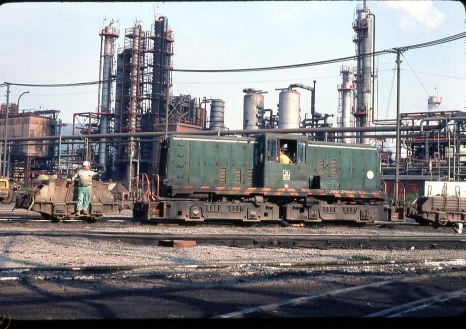
| Chuck Half posted Great view of J & L blast furnaces in background across the Mon River with Hot Metal Bridge linking to J & L South Side. Tracks below grade are Pennsylvania RR (Conrail/Amtrak) still operating within Tunnel Park under the new retail and housing of South Side Works. Dave Nemcsik: The locomotive is from the Mon Conn RR. |
 |
| Pete Steffey commented on Dave's comment The other end (East) of the Southside Mill . Photo by Kevin Tomasic |
6:55 video about what was here (source) Demolition was happening in 2016. "The plant was on both sides of the river." Steel making was on the south side. Five blast furnaces and rolling mills were on the north side. The galvanizing plant is still in operation as Galv Tech.
15 photos of dismantling P3 blast furnace to make room for new.