Showing posts with label towFanning. Show all posts

Saturday, November 10, 2018

Marge Mcfarlin and USACE Lock Database

I discovered that the US Army Core of Engineers has a web site that displays their lock activity. So purpose of this posting is to record interesting links as well as try to track were Marge goes during her stay in the Chicago area.

I can select which range of locks I on the Illinois Waterway for which I want data. I narrowed it down to Dresden Isand and Brandon Road. Most of the vessels were running light or with a small tow. (Although, the Lemont Trader went downbound through Brandon with 8 barges.) However, Marge Mcfarlin went upbound with 15 barges through Dresden between 03:59 and 06:43 on 2018/11/08. I recognized the name as one of Ingram's pushboats. Like Sam Fleming, it is a line-haul pushboat that has a retractable pilot house.

Marge Mcfarlin, USACE Vessel #0575287
So I started tracking its location in the Chicago area. Around 2pm, it was downstream of Mugz's Hideout. Theoretically, if I headed there, I might be able to get photos of it. But my main movtivation for getting a photo of a tow is to determine its size. But the USACE report includes the number of barges that locked through. It will be interesting if it goes through Brandon or if it stays in the Ingram's Channahon fleeting area. Since the weather has turned cold, I'll spend my time getting location updates rather than grinding out miles on the interstates to Mugz's Hideout. Some of the locks on the Illinois River were closed this summer for repairs. I checked the lock status page to confirm that the closures are done. The other tow through Dresden larger than 8 barges was the upbound Killian L. Huger with 13 barges.

Looking a Starved Rock and Marseilles, I was surprised to see that only two of the tows were larger than 8 --- 13 and 15. And our friend Sam M Fleming had the 15-barge tow. There were two light tows and tows as small as 2 and 3 barges. I expected the tows to be larger as we got into the mainstream of the river. For the two wicker dam locks (Lagrange and Peoria), of the 10 tows listed, only 8, 13, and 15 was larger than 3.

I did a query for all of the locks on the river. It appears to be sorted by vessel number. More accurately, the output is not sorted; it is displayed as it is stored in the database. Of the 35 entries, one was a pleasure craft (#9999999) through the O'Brien lock.
\
The large delays for Brandon in this output caught my eye.
Looking at the arrival times vs. the Start of Lock, it appears they made Derek, Aggie and Lemont wait until after Lousiana and Cody locked through together. And Aggie locked through before Derek because they had to lower the water anyhow before Derek could enter. Even Lousiana and Cody had to wait until 1am even though Capt cleared the lock at midnight.

1410:  273.2
1426:  271.2   It went backwards! It must be in some sort of holding pattern waiting for a (big) spot in the fleeting area. Now I'm glad I didn't take off to try to see it. The holding area is around a bend and not visible from Mugz's Hideout.
1445:  271.2   In fact, its 0500 location was 271.2. So it has been waiting a rather long time.
1512:  271.2
1612:  271.6
1715:  271.4
1816:  270.5   Ingram still shows upbound.

USACE shows downbound with arrival at 1415 and departure at 1745. So it is a good thing I never went to Mugz's Hideout because it was downstream of the bend all afternoon.


Query of Dresden Lock delays at 6:26

2019:  262,8   Ingram is still showing upbound. But, obviously, we can wave goodbye to Marge.

I was going through the photos posted for Mugz's Hideout and noticed this one. Unfortunately, I can't find the name on it. You can tell this is around a fleeting area because it is a line-haul pushboat that is running light. The photo also has a nice view of the I-55 bridges.

Michael Pesek
One last check on Marge before I click Publish:
11-10-2018  1440:  170.5   It was at 208.4 at 0500


Sunday, September 23, 2018

20180922 Erna E. Honeycutt is headed to Chicagoland

I'm not optimistic about chasing this one in the Chicagoland area because the last time I tracked her, it appeared that she turned and burned at the Channahon terminal.


Today's Google satellite image of the Channahon fleeting area is different. The barges in the upper-right corner look like the pile that was there in the previous image.

Satellite
20180922
1301:  276.3
1638:  278.2
1842:  285, so it is doing some local fleeting operations.
Rats, I got caught up in writing about Calaveras Dam and forgot to check more frequently this evening to see how far upstream she went.
2104:  291, Lockport Lock
20180923
0007:  291.1  Still in the lock
0125:  294.3  I had to first click that I was not a robot
0154:  295.5
0404:  298.8  Lemont Terminal
1035:  283  Would I have time to beat it to Mugz's Hideout?
1207:  278.8  In hindsight, I did have time to see what I could see from Mugz's Hideout.
1354:  278.4
2301:  255.3   There are now nine tows on the Illinois River. The furthest upbound is Dale A Haller at 244.4 (I forgot to get a fresh link for 244.4)

Dale A Haller
20180924
0343:  250.6  It has moved only 6 miles in almost four hours?  Did it serve a dock in the Seneca area?

20180925 
Noonish  277.3   Erna is back in town
1549:  273.5   But it left after a few hours?


Saturday, September 22, 2018

20180918 Sam M Fleming was hidden behind trees

While Sam M Fleming was heading upstream, Roy E Claverie was heading downstream. They met just downstream of the Dresden Lock.

Since Sam was heading upstream. On my way back home, I took US-6 to Bluff Road to drive down the roads to confirm that I could not see the Channahon fleeting area because of trees and No Trespassing signs.

Roy made good progress downstream:
2035: 244,8

The next day, I checked Sam:
1140: 298
It has gone upstream of Channahon, IL!
1144: 298.4
Is it going to stop at the Lemont fleeting area? Actually, since I learned yesterday that the web has a delay, did it stop?
1159: 298.8
I checked a little later, and it was still there, so I grabbed my camera and headed to the Veterans Memorial Trail.

I knew from previous trips that the Des Plaines River Drive has signs that indicate authorized personal only. So there is no trailhead parking for the Veterans Memorial Trail. Fortunately, there is a picnic spot on Bluff Road near the trail so that it is a fairly easy walk down  the Veterans trail to the Centennial Trail that goes along the marine terminals. As one would expect, a chain link fence with barb wire blocks the view of a crane moving the covers from one end of an empty barge back across the top of the barge. I remember when they did not put covers over barges carrying coal, gravel, etc. (Of course, it has been a while since I have seen barges carryhing coal.) I always wondered what happened when it rained. Now they seem to cover empty barges as well.

But I learned there is something far worse than a chain-link fence: nature. Not just trees, but bushes and vinces. Sam Fleming was probably somewhere on the other side of the vegetation on the left. The fence with the yellow top is the Asian Carp Barrier.

The one gap was where a gate used to be. I could see a crane working, but not the barge it was working with.

I bought a video editor that advertised a stabilization option. But the results are not near as good as what YouTube did before they pulled that feature. And the program made my video files disappear from File Explorer and Photo! At least I installed it only on my laptop. File Explorer and Photo still work on my desktop. Since this was the first time I have seen a Link-Belt boom extend, I extracted the boom movement part of a video. If anybody knows of a good stabilization program, please recommend it in a blog comment.


When I got home, I verified Sam was behind those trees. In fact it stayed there for at least a few hours.
1444: 297.7
1458: 297.7
1647: 299.4
1929: 299.4


20180919   0522: 291.1, Lockport Lock. Even if the web did not have a delay, I don't think I could beat it to Joliet. And I determined that the next accessible viewing spot is Morris. By then, it has passed the Channonahon fleeting area and will be pushing a standard 15-barge tow. Plus, it might rain today.

1222: 287.2  Wow, it is still doing its own fleeting operations. It is now in the Joliet fleeting area, which is easy to view from the US-6 bridge. I got more photos of that area just two days ago. At 0500 this morning, it was at 292.

20180917 5808


1754 : 283.9  It has gone through the Brandon Locks because it is now down by Caterpillar.
1858:  279.5  The icon has changed from upbound to downbound. The direction column also has an "In Port" value, but I never saw that on the web page while it was in the area working the industries and its marine terminal.
1913:  278,9  So how long is Sam going to stay at the Channahon fleeting area?
1942:  278.1
2204:  278.1  Looks like Sam is staying here for the night. I wonder if the crew of the boat lives in this area and they have been getting shore leave during the nights it was in the area.
20180920    1626:  249.9  It looks like it has its 15 barges and is gone.
20180921    1419:  213.2
Last night it was on the Mississippi River a little downstream of the Illinois River mouth. It must have swapped tows quickly at a Mississippi facility because it has made good progress back up the Illinois River. In fact, she was at 159.2 at 0500 and is headed back downstream.
20180922    1301:  152.9


Ingram
1907:  The next closest tow is Marge Mcfarlin at the CGB elevator near Utica (229.4). It is like Sam --- a line-haul boat, but with a retractable pilothouse.

1911:  230.3  CGB just happens to be where I caught it. It is now upstream of IL-178.
1942:  230.7  It is now in the Starved Rock Lock. It should be here a while because 15-barge tows have to be split for two lockings.
2204:  230.8
20180920    1626:  268.1
20180920    1419:  it was at 273.2 at 0500 and is now back down to 253   The crew must not be in this area because it turned and burned.


Ralph E. Plagge might also be headed to Chicagoland.

20180920   1626:  237.9
20180921   1419:  271.1  Probably waiting for Dresden Lock
20180922   1301:  259.2  Ralph was at 279.2 at 0500, so she has turned and burned.

Now Erna is the furthest upstream.
20180922   1301:  276.3

Wednesday, September 19, 2018

20180917 Roy E. Claverie, missed it at Morris, IL; can't see anything at Channahon

I drove to Morris, IL to catch this pushboat going downstream. While I ate lunch, I tracked its progress and when it was getting close to where I wanted to catch it, I was done with lunch anyhow and took off to get it.

Ingram Barge
1237: 265.8
1239: 265.8
1249: 265.1
1243: 265.1
1247: 265.1
1251: 264.5
1253: 264.5
1259: 263.8

I never saw it. I went back to the bar and grill where I ate lunch to access the WiFi again. It showed it was where I just left the river!

When I went to the riverside park, I asked someone who had been setting there if he saw a tow go by. He said: "yes ,two of them." He estimated that they had gone by in the last 20 minutes. So the web site does not show the location in real time. There is evidently a 5-20 minute delay.

I did determine for future trips that this building seems to be an xfinitywifi hot spot. And the parking lot behind it is free.

While I was by the river, I did hear a train (CSX or IAIS) honk its way through Morris. It sounded like it was going westbound.


20180920    1626:  75.7
20180921    1419:  200.7 on Upper Mississippi.  It was 20.5 at 0500. So was it still on the Illinois at 5am?


Saturday, July 28, 2018

20180716 Sam M. Fleming "stuck" near Hollywood Casino

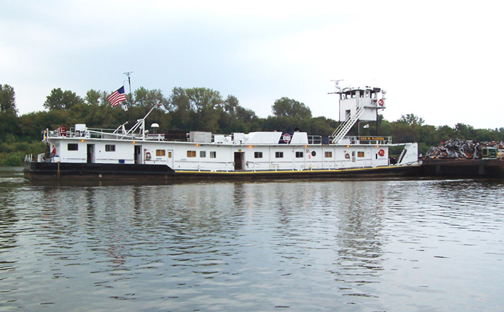
I had been following Sam M. Fleming on Ingram's web site after I chased it from Joliet to Lockport on 20180708. It had gone down to the Peru area, but on the morning of July 16, I noticed it was a little downstream of the Brandon Lock. Since I spent more time trying to get more photos of it, I wanted to dig deeper into its specifications because I think this is the largest pushboat I have seen with a retractable pilothouse.

20180708 2774

Satellite
Since I started tracking it on 20180708, the furthest I have seen it from the Chicago area, where a retractable pilothouse is needed, is a little downstream of Hennepin. In fact, it been there for over a day now. This morning (July 16) it was still at milepost 205.4, and, as I write this (5:35pm), it is still at 205.4. But it also spends time on the Ohio River per Flickr photos by Joseph Schneid  at mile 619 and at Louisville. So it does do line haul work. Joseph's comments provides the stats for me:
Sam M. Fleming
0590071
Length 144 feet - Breadth 35 feet - Twin Screw GM 12-645E7B, 4300 hp
Built 1977 by Nashville Bridge Co., Nashville, TN Falk red. 4.48:1. Kort nozzles.
Retractable pilothouse
Originally William F. Earthman
Renamed Sam M. Fleming 1995
Owned by Ingram Barge Co., Nashville, TN

I discovered that he got this information from TowBoatGallery. That is good to know. I looked at several web sites to find information. Most of them claimed to be tracking sites, but the data was way out of date. One was as old as January!

I noticed in Joseph's photos that Sam displays the Ingram logo whereas in my photo it displays Inland Marine Service, but it is still listed on the Ingram web site. Gary Whittington also caught it on the Ohio River with the Ingram logo at Paducah, KY.

A retractable pilothouse for a line haul pushboat is rather rare. It has such a long deck house because the living quarters for tow crews have to be included in that deck. Normally a line haul pushboat has several deck levels and the higher levels have the captain's quarters, galley, bunk house, etc. I wonder were else on the inland waterways there is a height restriction of about 16.5' to justify a low-profile line haul pushboat. Because of their very distinctive profile, I have found two more to research: Mr. Chuck and Ned Merrick.

Satellite
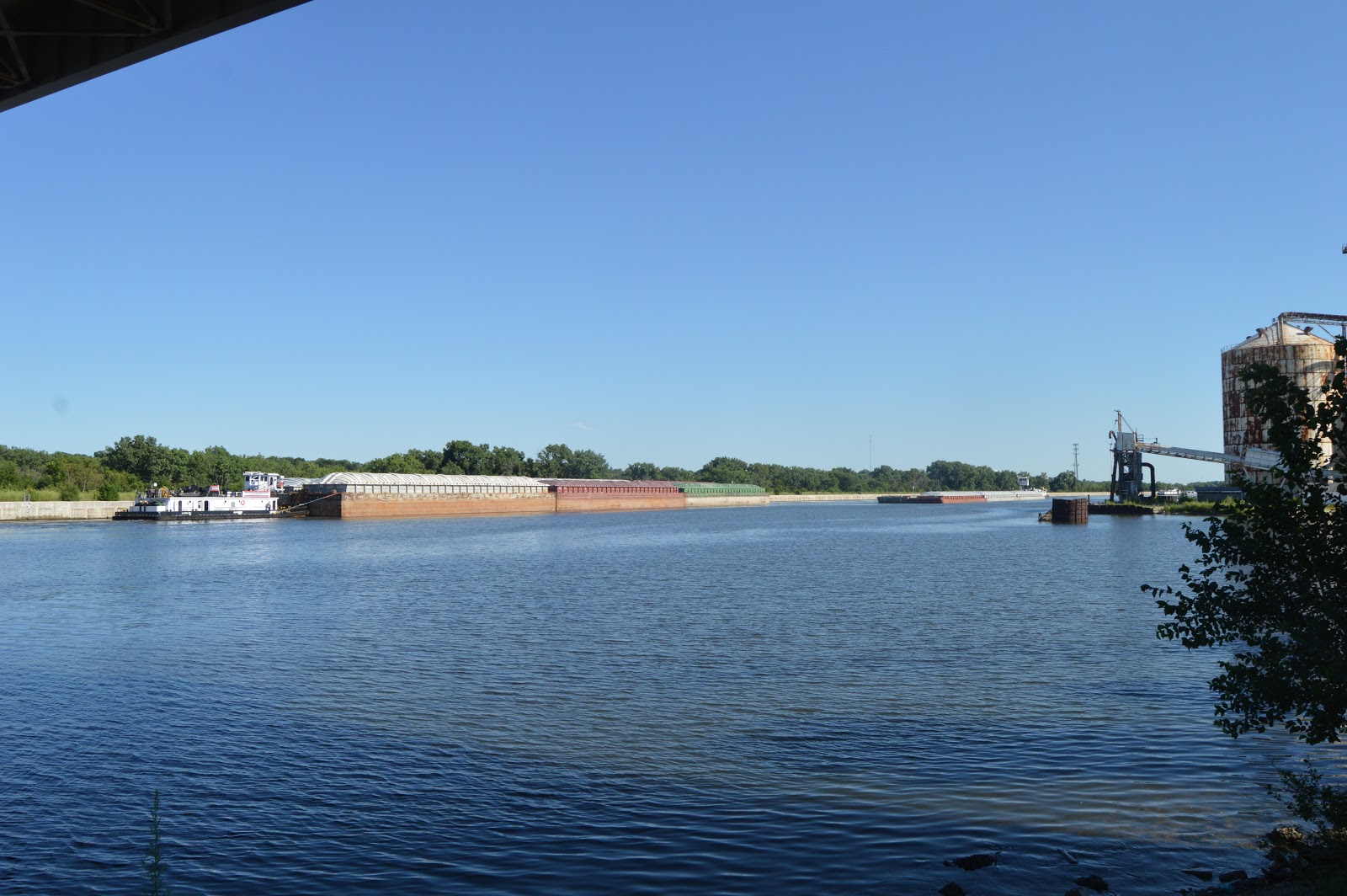
I mentioned in the first paragraph that Sam was downstream of Brandon Lock. When I checked again around noon, I noticed it was in the same place --- near Hollywood Casino. Until I noticed Hollywood Casino, I thought the Des Plaines River downstream of Brandon Lock was just industrial. It looked like maybe I could get a view of the tow from the casino's parking lot. Since it appeared the tow was going to stay there for hours, I went there to see what I could see. In particular, I wanted to know how big of a tow it was pushing. I assume it left Peru with a 15-barge tow and dropped barges off along the way.

Between the parking lot and the river was a heavy treeline. But then I discovered a concrete culvert that created a gap in the treeline so that I could get this shot.
20180716 2877
I could tell that the tow was three barges long and 3 barges wide at the front --- two tanker barges and a covered hopper barge.

But I could not tell if it was three barges wide at the middle and rear. If it was, then the starboard barges were loaded barge and did not have covers because I could see them in the photo if they were empty and/or had covers.

The significance of the starboard rear spot being empty is that the pushboat could move into that spot when going through a lock.

I went down the road to the loading dock on the west side of the casino to see if I could get a better view of the pushboat. Given that the following are the only two views I could find, the answer is no.
On my way back home I stopped at the visitor center for Brandon Lock. I first noted that the construction office trailer that had been parked in the parking lot was gone, but the Manitowoc 777 crane was still parked by the lock. This photo was taken legally from the sidewalk that goes up the bank to the visitor center area.
Next I took my camera into the visitor center, which a sign at the gate forbids. I wanted someone to come out to talk to me so I could ask when they expected Sam to lock through. No one came, so I took a photo of a little Grove crane at the southwest corner of the lock. (Closeup below)

Since I still wanted someone to come out and challenge me, I took a shot of the 777 as well. It is parked on a barge.

It has been parked there long enough that Google has captured an image of it.
3D Satellite
I gave up trying to attract someone's attention and went home. But I think the small crane construction activity explains why Sam was stuck downstream at least half a day.

I repeat the above noonish position that was almost identical to the morning position for easy comparison with later positions.
Satellite
After I got home, I sampled its position around 6pm. My first thought was that it had headed downbound. But then I decided that it just wasn't using a lot of fuel for "station keeping."
Satellite
I took another look around midnight. It confirmed that it was waiting to go through the lock but the caption was not bothering about accurate station keeping.
Satellite
During the night, it finally was allowed through the lock and made its deliveries and picked up a new tow because the next time I looked, it was back downstream of Hennepin.

Before and during most of the day of 20180719, 205.4

I don't see anything on the satellite image at 205.4, but there must be a new loading dock or something because this is the second time I have caught it spending quite a bit of time there, and then it heads back to the Chicago area.

But when I looked at 8:51, it was at milemarker 216.3. So even though a direction icon on their web site still showed that it was downbound, it is obviously headed upbound.

2133: 217.4
2313: 221.2
0034: 225.1
Satellite
0104: 226.4  When I looked at this position, I noticed two 2x3 tows in the image. So they do some rather small tows on the Illinois River as well.
0224: 226.4  Are they stuck in a queue for Starved Rock all the way back here??
0455: 229
0753: 231  in Starved Rock Lock
1134: 242
1242: 244.3, I happen to notice that the icon has been changed to upbound.
1303: 244.3 Looks like they are waiting for the Marseilles Lock.
2321: 269.4
2354: 270.1
20180721
2255: 278.2 upbound
20180722, I was out of town
20180722
1719: since 0500 it has been setting at 278.2
2209: 271.4, the icon is showing upbound, but the mileage difference indicates downbound
20180724
0008: 269.4, icon is still upbound
0236, 03:52: 266.4
0500: 264.3
1045: 249.1, someone finally changed the icon to downbound
1247: 245.2, it looks like it has been waiting for its turn to go through the Marseilles Lock
1436: 245.3, still waiting for the Marseilles Lock
1830: 233.3, it looks like it is waiting for the Starved Rock Lock
2047: 231, it is in Starved Rock Lock
2142: 230.2, must have gotten out of the lock just a little bit ago
2306: 225.2
20180725
0045: 219.3
0500: 208.5
0711: 209.4, they have an "In port" icon, but it is still showing downbound. Marquis Energy talks about exporting DDGS and eth
anol using the Illinois River, but the satellite image shows Marquis Marine transloading grain from truck to barge. A photo shows transloading barge to truck with a clamshell crane.
1349 198.3, lots of barges being loaded with aggregate. And they have there own little pushboat.
1532: 185.1, so I guess they just happened to be passing by the above aggregates barge loading facility
1823: 174.3, it looks like it might not be coming back to the Chicago area like it did before.
2028: 164.1

2220: 158.1 I wonder if the river's water level is high enough that it can skip the lock. This satellite image shows the river level is so high that it covers  the lock walls. That means the wickets are down so that they can use the river channel.
20180726
0500: 144.3
1038: 141.2, so why did it take over five hours to go 3 miles? I don't know where the second wickets dam is on the Illinois.
1529: 153.4, So it was at 141.2 for so long because it was getting a new load for Chicago? If so, it must be a new business because I don't see a loading dock on the satellite image.
20180727
0017: 166.5
1403: 205.3
2102: 222.4
20180728
0500: 225
1019: 234.1
2218: 248.3

Obvously, it is not going to make it back to the Joliet by July 29. Since I'm going to be out of town next week, I'm going to quit following Sam for a while because I won't have a chance to chase it in the Chicago area. So it is time to publish this look at Sam's trips on the river.

Update: actually, it looks like it spent some time at Ingram's Channahon fleeting area, then headed downbound. You don't need a retractable pilothouse for that.

20180804 1322: 208.1 on the Upper Mississippi with a downbound icon
20180806 0907: 182.1 after spending a couple days upstream of Alton, it looks like it is headed down the lower Mississippi River. The are now just three boats on the Illinois River, Brian A. Napack is the closest to Chicagoland at 179.
20180807 1718: 194.3  It has been setting here since at least 0500. The icon indicates upbound.
20180808 2255: It has been setting at 194.4 since 0500.
1836: 11.3, it has started back up the Illinois Waterway
20180810
0234: 53.1
0500: 61.1
1117: 80.7
1535: 85.2, just 5 miles in 4 hours? I looked for a lock, but I did not find one.
20180811, stuck at 85.2 or 85.1 all day
20180812  1048, 2124:  85.1
20180813
1708: 85.1
2320: 81.8
20180814
0254: 81.8
2010: 85.1
1843: 85.1
2129: 85.1
20180816  1045: 89
20180817
0018: 124.3
1113: 151.6, lots of tows in this area. A fleeting area?
1452: 151.6
20180818
0711: 192.8
1809: 218.9
2339: 228.6
20180819
1256: 231.8
2137: 255.5
20180820
0500: 245.1
0635: 236.7and icon shows downbound, at ADM Growmark
20180821
0500: 228.3
1034: 221.7, Brian A. Napack (no photo) is at 268.5, but the next day was down to 250.5 with a downbound icon; Marge Mcfarlin (retractable pilot house) is at 278.5, but the next day was down to 221.8 with a downbound icon; five are on the Illinois Waterway. Since I'm out of town, I'm going to quit following the tows for a while.
Erna E. Honeycutt
20180829  Sam is at 234.8, but the icon shows it is downbound. However, Erna E. Honeycutt is at 238.2 and upbound. So I will start tracking Erna now.
2151:  277.1
20180831
0500:  278.1
1119:  272.1  So it changed tows at the Channahon fleeting area and is heading out of the area. This makes sense sense it is the purpose of a fleeting area to have a tow assembled by local pushboats so the line-haul pushboat has a quick turnaround. The local pushboats will then disassemble the tow and distribute the barges delivered by Erna. When the leaves are off the trees, I'm going to have to make a trip along Front Street to see what I can see.
20180903 1140:  Brian A. Napack is the furthest upstream at 251
20180904  At 0500 it was at 278 and at 1808 it was back down to 245.9. So it must have also swapped tows at Channahon.
Marge Mcfarlin is now the furthest upstream at 253.2
20180905 11:47 278.7, but thunderstorms are on the way. Wow, by the end of the day it was all the way down to around 266
20180907 1239:  Dale Heller is at Channahon, but it is raining today.


Thursday, July 19, 2018

20180708 Sam M. Fleming Pushboat Chasing (passed Al Weaver)

While I was researching flanking, I came across a web site for Ingram's pushboats. I searched for all of the pushboats that were running on the Illinois Waterway. The one at the highest mileage marker was Sam M. Fleming. Fortunately, Ingram's web site offers a link to its position on Google Map because I didn't have any clue about miles on the waterway.

A couple of highlights of the photos below:


Sam M. Fleming

Position: Mile 279.3 on the ILLINOIS WATERWAY
Net Tonnage: 474
Engines: GM 12-645-E7B
Boat Height: 16.6FT (Highest Fixed Point: 42.1FT)
Length Width: 144X35FT
Boat Draft: 10.6FT
Locate this Vessel on Google Maps

David Gulden posted
WILLIAM F EARTHMAN now the SAM FLEMING

When I first checked Sunday morning (Jul 8 2018), it was just below Brandon Lock. When I checked after I got up for the day around 1pm, it was just south of US-6 at the Joliet fleeting area. So I wondered if it was dropping off a tow and picking up another to go downbound like I have described for the Leo G. Lutgring. I decided it was worth driving to Joliet to check it out. To make a medium story short, I not only did not see Sam (I recently read that proper usage is to use the first name.) in the fleeting area, I so no barges there.

After stopping to take some photos of the completed new Joliet train station, I noticed in the distance that the blue Ruby Street Bridge was up. So I quick headed to that bridge to see if it was approaching the CN/EJ&E Bridge. I did not see the tow upstream.
20180708 2737
I checked out the river overlook in Route 66 Park. Unfortunately, it is now like the Newburgh Lock Overlook, they need to offer someone free firewood if they would cut the trees.


On my way into Lockport, I turned onto the old 9th Street. I discovered that the Old 9th Street Bridge, which I have used in the past, is now closed. So I continued on to Lockport, hung a right into the public parking lot south of 9th Street before the CN/Metra tracks, confirmed Embers Tap House had WiFi, and had a nice meal while I confirmed that the tow was at the Lockport Lock. I killed time exploring the area trying to find somewhere to view the canal. You can tell that the current 9th Street Bridge was built a while ago because it has no accommodations for bikes and pedestrians. The road near the canal's controlling works doesn't allow you to see the wake and propwash of a tow.

I went back to Embers and spent some time in their "waiting to be seated" area, which was empty, reading Facebook and checking the location. Everytime I checked, it was still in the lock. So I gave up and headed home. But as I crossed 9th Street Bridge, I saw a couple of guys walking across the old bridge. Once again, fisherman teach me how to access a waterway.
So I went back to that bridge and parked behind their Jeep, grabbed my canvas chair, a magazine and my camera; and I walked across the old bridge.
As I had crossed the current bridge, I grabbed photos to the north (upstream) and south (downstream). (I'm not taking my eye off the road. I just hold the camera one-handed and shoot at 18mm. Then I use Gimp to rotate and crop the part I want. And I'm driving a minivan so I can sometimes get a decent image above the handrail.)

20180708 2743rc, looking North
You can see a downbound tow on the right passing "double parked" barges on the left. We will see much more of that downbound tow shortly.

Looking South
The small 1x1 downbound tow is waiting for an upbound tow to clear the Lockport Lock.

There is a curve in the canal, so one cannot see all the way to the Lockport Lock from the 9th Street Bridge, but there was no upbound tow in sight.

After I walked across the old bridge, I discovered there is an area by the canal with no tree line right under the new bridge.
5:14:47  In addition to a bird taking off, I saw not only the tow that was parked on the east bank, but an upbound tow.
 5:14:51 And the tow that was coming downbound is going past me.
 5:15:14
 5:15:23
 15:16:21  Below I digitally zoomed in for a close up of AL WEAVER.

5:16:24  I realized that the downbound tow was parking by the side of the canal.
5:16:26  And that the little tow that had been parked had left.
5:16:29  I took this photo because I noticed the significant propwash. Actually, I probably heard the diesel engines and that alerted me to take a closer look at the stern of the pushboat.
5:16:44  A lot of water moved, but the tow did not move downstream. It must have been shoving the front end of the tow against the canal wall because it will be parking for a while.
5:17:03 Here we see all three tows, a glimpse (note the green cover) on the left of the tow that just parked, the upbound 2x3 tow in its entirety, and the little downbound tow to the right of the old grain loading facility.
5:17:20  Note the parked tow has retracted its pilothouse. I realized that the little tow I had seen parked earlier when I was crossing the 9th Street Bridge was waiting its turn to go through the Lockport Lock. After the upbound tow had cleared the lock, the little downbound tow could leave for the lock. And this big 2x3 tow behind it had to park and wait for the little one to lock through. The good news is that the little tow will fit in the 600' lock without any disassembly. When the 2x3 tow reaches the lock, it will have to remove the pushboat from the barges and pull alongside them to fit into the lock.

5:17:59  The upbound tow makes steady progress.
5:19:10
5:19:37  Clearly, a 2x3 tow.
5:20:14
5:20:21  There is enough action I don't want to read my magazine, so I took a photo of the abandoned grain loading facility while I was waiting for the upbound tow to pass.
5:21:02
5:21:26  Then I got excited when I could read the name of the pushboat: Sam M. Fleming for the Inland Marine Service. It is interesting that it does not carry an Ingram sign. So I got the answer to the question I was after, how big of a tow was it pushing up the canal --- 2x3.

 5:21:49
5:22:11  I then switched to video.
(new window)

5:22:59 You can tell from the relatively small propwash that the Chicago Sanitary and Ship Canal normally has a slow current.

5:23:23  And the Al Weaver is still parked with its pilothouse retracted.


I stopped and went out on the 135th Street Bridge, which not only has a pedestrian/bike lane, it has a nearby trailhead parking lot. But the tow was too far south to wait for it. I went home and periodically checked its location using the Ingram site. The furthest upbound I caught it was in the Cal Sag close to Donegal Excavating.

Satellite
I suspect it delivered barges to Ozinga because when I checked later it was downstream at the following location. The pilot house had to be retracted for every bridge going upbound starting with the BNSF/Santa Fe bridge in Lemont.
Satellite
I noticed the "dot" was close to a lot of empty barges. Then I determined that this is Illinois Marine's Channahon fleeting area. When I checked again the next morning (20180710 7:00am), Sam was still here.
I checked its location periodically over the next several days, and Sam made a trip to the Peru area and then back to the Chicago area. Once it spent many hours (more than a day?) just upstream of the Brandon Lock.