My daughter needed to get something near Ogden and Racine, so I rode along so that I could take pictures of railroad stuff. Because it was the day before Thanksgiving, traffic on I-290 was worse than usual, so her GPS had us get off at Sacramento Blvd. and use side streets. After she got her package, we went south on Racine and Ashland to 49th street so that I could determine if the 49th street flyover still has wooden bents. (It does.) Because traffic was also bad on I-55, the GPS gave us an alternate route using side streets. We did the alternate route back home because I already have seen the city from I-55. This trip provided many views that I have never seen before.
I don't normally see a train on this IHB overpass. You can tell we have just had a harvest season because it looks like a unit grain train. I see a satellite image caught a loaded coal train and an auto train.
This overpass is for the
Blue Line near the end of its route.
The CSX/B&OCT/Wisconsin Central overpass. It looks like I did not give the autofocus enough time to find the focus since we were travelling at highway speeds. It is blurry even though the shutter speed is a relatively fast 1/250.
We are coming up on the
Ferrara Candy Company. This is the last industry that still uses rail service on this CSX/B&OCT east/west route. I counted 17 hopper cars parked at the plant on a satellite image.
On the right is the beginning of the embankment that will take the CSX tracks over the Blue Line and the Eisenhower.
The west side of the candy factory seen through the Harlem CTA station.
The plant has some interesting stuff on the east side of its roof. And we are now seeing two rows of some of the covered hoppers parked at the plant. Below I cropped out the sky to get rid of the sun and then increased the brightness and contrast with Gimp. Unfortunately, I still have the glare of the car window.
I count three legs in this shot and we see more hoppers.
The end of the cut of hoppers and the best view of their sign on the corner of the building.
This area of Cicero used to have a lot of rail served heavy industry such as foundries. It is nice to see some of the buildings still house industry. Although they no longer use rail service. It is hard to see in the photo, but the left side of the lower building is curved to accommodate an industrial spur, and it looks like some tracks used to go into the building.
The long building in the background is part of the
Chicago Studio City, a film production company that takes advantage of the size of the industrial building to provide
four sound stages.
Another building that has a curved east side to accommodate an industrial spur.
CSX uses a lead to these industrial spur remnants to store some MoW equipment.
I'm trying to catch the sawtooth roof on the left side of the photo.
I notice the sawtooth roof is really big. But in practice, these photos are really reminders to check out what is here in a satellite image (below).
Note below that another building is curved on the east side indicating another industrial spur was here.
This is the BRC overpass. Note that you can see the top of the Willis/Sears Tower above the tree that is to the left of the two balloons. Trains going to the Ferrara Pan Candy Co. use the BRC to get to the B&OCT tracks because the city condemned some of the bridges on the B&OCT route east of BRC. I've read speculation that Mayor Daily condemned the route as a favor to some of his cronies for their new real estate developments. A quick look at a satellite image shows the double track is still intact into the city. Maybe they just wanted to get rid of the sounds of nearby trains.
The image on
this building is changing more frequently.
I'm glad I took a closeup of the BRC logo. I didn't realize that what I was seeing was a shadow until I looked at this photo. The logo is a metal plate that is offset from the bridge with some metal rods. The overpasses over I-290 are becoming examples for model railroaders as to what "weathering" looks like.
 |
| Digitally Zoomed |
The traffic on I-290 was so bad that the GPS had us get off on Sacramento and then go over to Francisco to go north to Lake Street. Thanks to a vacant lot, I was able to get a shot of an "L" train on the Green Line.
We see some of the stairs that go up to the
California Station.
The industrial building behind the trees that still has the base of its water tower caught my eye. Also note the Willis/Sears building peaking over the building that is so blah it really makes you appreciate the design of the older buildings. But the main reason for keeping this photo is the "river of steel" that is above you when you drive down Lake Street.
That old manufaturing building used to have
a railroad siding at its second floor. It has been
repurposed as rental lofts.
The "L" switched to wider supports so that it was no longer nerve racking driving down the street. The "L" is going up while the road is going down to cross the
Western Avenue Railroad Corridor. Note the depth of that cross girder for the "L."
Girders for as far as the eye can see.
The Pink Line joins the Green Line
here for shared access to the loop.
We turned northish on Ogden Avenue so I couldn't resist getting a couple of shots of the
ADM Flour Mill as we passed it. The mill has been sold because the gentrification of the Fulton Market area has made the property too valuable. Also, a lot of the big bread bakeries that where in the Chicago area have closed (e.g.
Schulze, which made Butternut Bread). ADM is building
a replacement mill in Mendota, IL.
It still has four rows of hopper cars to supply wheat.

When we were done with the errand, we headed south on Racine because I remembered that it crosses the Metra/Milwaukee at grade level. This shot is looking West from where we were able to park the car. We can see a leg and headhouse for the ADM mill in the middle and some of the new gentrification buildings on the left.
This signal bridge is the reason I wanted to stop at this crossing, but I first took this overview shot of the skyline because some buildings have been torn down to open up the view and soon this view will probably be blocked by new buildings. Note the boom of a tower crane on the right.
In the background near the right is part of the "
bridge to nowhere."
A better view of that bridge. In the background is
another neat old industrial building that still has its water tower base.
 |
Digitally zoomed
Note how light the truss members are for rapid transit compared to a bridge that can carry 286,000 pound freight cars. Also we can see the signalling heads near the bottom of the bridge. |
These are classical Pennsylvania position signal heads with the
red-eye modification. The
Pennsylvania Panhandle and the Milwaukee used to share this route to the north side of
Union Station. The Pennsy heritage of this route is probably why Norfolk Southern handles the freight service on this part of the Metra line. Specifically switching the covered hopper cars of the ADM Flour Mill. You can tell that Metra is behind with their implementation of Positive Train Control because this bridge will be replaced by the new tri-color signals.
 |
| Digitally Zoomed |
While I was here, I took a shot of what was north of the tracks as well since the skyline will probably be changing in this area also. The tall black building to the right of the light pole is the
John Hancock.
I'm glad someone decorated this water tower because now they don't want to tear it down. I wonder if it is the last water tower standing in Chicago. Nope. I saw
another one later in this trip.
When I went back to the car I continued on north and took a picture down Kinzie Street to capture the water tower base and the old signalling bridge. There must have been a small railyard up there. Also, the old signalling bridge frames the north end of the "bridge to nowhere."
Another angle of the skyline.
We are headed west on Carrol to try to get a better picture of the "bridge to nowhere"when I spotted this flour truck trailer parked on the east side of the ADM Flour Mill. Unfortunately, it is hidden in the shadow of the building.
We did not spend a lot of time on the quest so we did not find the "bridge to nowhere."
When I came down here to take pictures of the mill, it was on a Sunday, and there were no cars parked on the street. That is why I normally do my field trips to Chicago on a Sunday.
I sure hope the gentrification of the neighborhood into piles of condos and apartments doesn't destroy
this building. The zoning laws have recently been changed so that 750 acres of industrial property can be redeveloped as residential and commercial (e.g. Menards) buildings.
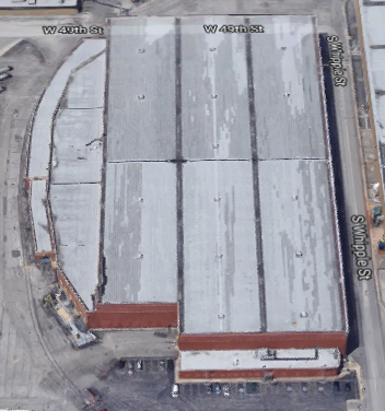
As we were driving south on Ashland to 49th street where I wanted to get some pictures. This is the best view I caught of four big smokestacks. Considering all of the fans I see on the roof in the
3D Satellite image, I assume this plant makes hot water in the winter to heat the UIC buildings and ice at night during the summer to provide ice water to the buildings for cooling.
We are approaching the lead tracks of
UP/C&NW Global One Intermodal Terminal.
The camera must have "thought" the bright container train on the next overpass was back lighting because it really overexposed the green containers. We are under the UP overpass and looking at the BNSF overpass.
 |
| Brightness reduced by the maximum that Gimp supports, -127 |
 |
| b-100c+100 |
We are crossing Cermak Road. Note in the middle of the photo that there is still a railroad crossing signal.
As we crossed, I turned to my right and realized that I think this is the part of the old
CB&Q Industrial Park that is still active.
We are approaching the Ashland Avenue Bridge over the Sanitary and Ship Canal.
As I went over it, I rather blindly took pictures to see what I could grab. This one turned out to be interesting. It appears the
Chicago Yacht Works has rented some extra cranes to help with the Fall rush of getting boats out of the river and into winter storage.
 |
| Digitally zoomed |
Another view of the
GM&O bridge.
Those industrial buildings in the distance made me realize that Ashland goes along the west side of one part of the
Central Manufacturing District.
The brick building next to the semi truck is a remnant of the
Wrigley Gum Factory.
This big white building used to have a lot of rail service. Some of the tracks went inside the building.
The neat brick building on the corner is still standing, but according to a satellite image, a brick building with a tower just to the south of it was recently torn down.
Fortunately,
another brick building with an office tower on it is being renovated. It also has an intact water tower to the left of the brick tower. The tower probably had "penthouse offices" for the big wigs.
But the building immediately south of it is not included in the renovation. In this block, we see a couple of curved buildings that indicate where industrial spurs used to run.
The remaining blocks north of the NS/NYC/
Union Stock Yard and Transit Company overpass don't have any historic buildings.
On the other side of the overpass, there was a McDonalds. This was great because it not only gave me a legal parking space to get out and take pictures of the action on the tracks, it let me go to the bathroom and get a hot-fudge sunday. I've learned before that finding a gas station or public bathroom with convenient parking near downtown Chicago is an issue. I include this photo because it captures that the UP locomotive has not yet touched the two NS locomotives. It arrived from the east as we were parking.
Behind the Swap-O-Rama sign in the distance is the brick building with a tower that we saw above.
On the left there are more brick buildings with that Central Manufacturing District architecture, including another tower. I'm saving 3D Satellite images of these older buildings because you never know when they are going to be torn down. There are also two more NS locomotives in front of the brick building --- #x197 and #7570. I think the "x" is a 5 and not a 9.
.
These locomotives are NS #1149 and #6921 and UP #7138. At this distance you appreciate that the UP numbers are bigger than those of NS.
When we arrived and while I was taking pictures, this truck was being filled with water from the fire hydrant. The worker has turned it off because it is no longer squirting water across the sidewalk.
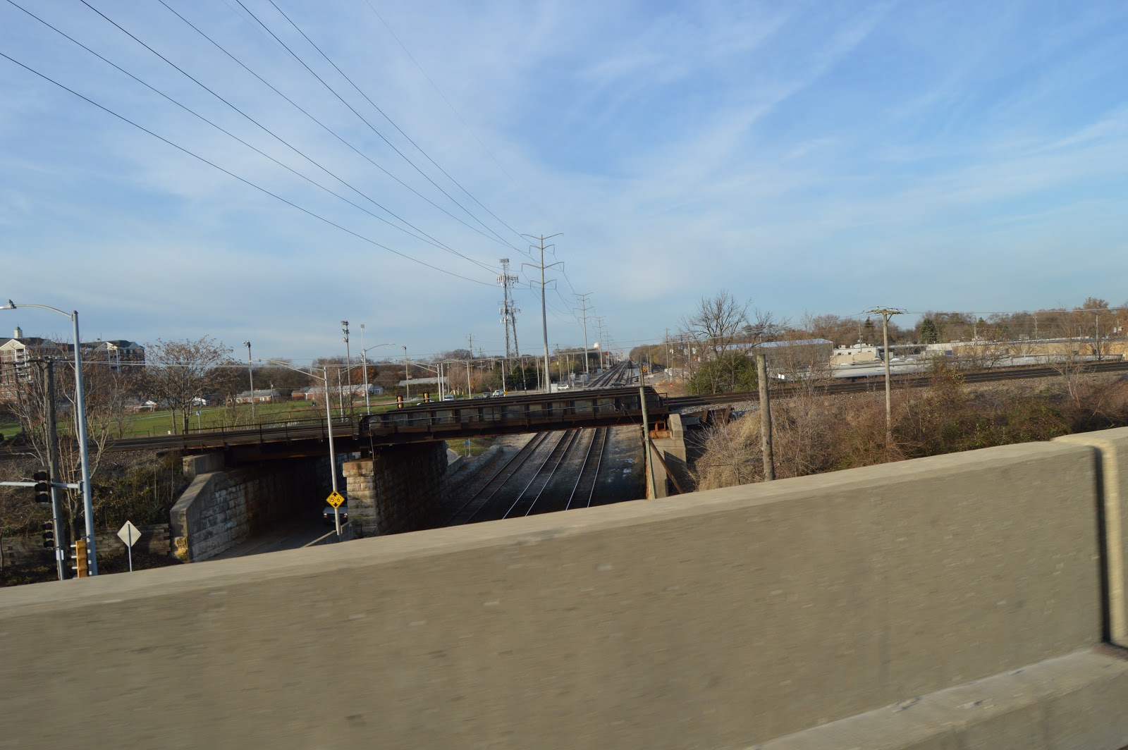
This was my destination ---
an end of 49th Street to see if the bents of the flyover bridge were still wood. They are!
I walked a little bit into the woods to get this shot.
I'm fighting a low Winter sun. I think the orange spot is some sort of glare off the lens. But the photo does catch that
the tracks have been severed east of the flyover connection.
I braved trespassing further onto someone's land, but the shot of the wooden trestle is not much better than the one I had already gotten. My daughter pointed out that there was a sign on the building next to us claiming video surveillance. She must have been looking for the camera while I was taking pictures because she said she could not find one. (This photo was used in
49th Street Tower.)
This overview of the end of the road shows why I did not walk down the obvious path in the first photo --- it was explicitly chained off.
And this is the sign that was on the pole towards the left of the above photo.
This is a view looking East to show the embankment to elevate the tracks over the residential neighborhood. The south two tracks were built by the GTW, and the north two tracks were built by the
Chicago & Indiana State Line Railway. The later is more commonly known as the Chicago Junction.
We parked again on 49th Street at Hoyne Avenue so that I could get out and take some detailed pictures of an example overpass.
I walked south of the overpass so that I could get the sunny side.
The use of a wide dirt embankment and a continuous abutment shows these two double-track routes were not only built at the same time, 1980, they were a joint construction project. This photo also shows what you can see in satellite photos --- the north two tracks have not only been abandoned, the overpasses have been daylighted. I've noticed that, in general, remarkably few abandoned overpasses have been removed in the Chicago area.
We are on the road again (51st Street heading West). We are approaching the Western Avenue Railroad Corridor overpass. We could easily see that a north bound train with empty intermodal cars was on the bridge because of the movement. As I suspected, it is very hard to see those cars in a still photo.
But if you look to the left of the overpass, you can see a SWIFT container approaching the overpass.

When I got on the other side of the overpass, I looked back over my shoulder and did find a gap to catch some of the containers on the train. Unfortunately, the photo is incredibly blurred. It was a sunny day, so I would expect a decent shutter speed. The metadata shows 1/160. We were travelling slow enough that I would think that shutter speed should have been fast enough to prevent blur. The f-stop was f/6.3, which is small enough that I would think the fence would be in focus. Maybe not the bar in the car window, but I don't care about that. My current theory is that I did not give the autofocus time enough to do its job before I tripped the shutter since I was in a hurry because this gap was closing as the car moved. Despite the focus issue, the photo captured the info I was after --- there was a block of double-stack containers. In fact you can see the train not only has a mix of domestic (53') and international (40') containers, it appears to have a mix of domestic and international platform cars.

Another smokestack to research.
It is the
Western Avenue Pump Station.
You hear about intermodal service being eco-friendly about reducing carbon emissions. That is true out in the country where the air is relatively pure. What you don't hear is the increased pollution in the city because so many more trucks are being dumped on the city streets. I suspect that these two are headed north on Western Avenue to go west on Pershing Road to
the BNSF/Santa Fe Corwith Yard.
Another angle on that smokestack to help me locate it when I get back home.
It is the
Western Avenue Pump Station.
I was shocked to find
a modern steel company in Chicago.
I grabbed this photo because in the background you see a container train going over the California overpass.
 |
| Digitally zoomed |
In the gap between the buildings we see some J.B. Hunt containers. That makes sense because J.B. Hunt built
a freight handling facility in the Corwith Yard where Santa Fe used to have their LCL freight house.
 |
| Digitally zoomed |
The Central Steel & Wire company has several buildings occupying several city blocks.
Plant B must have been an expansion by buying an older building because this building has a curve on the west side indicating an industrial spur. In fact, I see the track still exists.
Looking some more at a satelite image, I see there are five coil cars parked on a siding on the north side of the property. Now I understand some comments I have read about this plant is switched by the IHB.
Another smokestack alert. Unfortunately, I can't find a name
for the company. The stack is making money because it is being rented as an antenna tower.
 |
| Camera Resolution |
Crossing the CSX/CN/GTW route, looking North. Since a photo below shows that a container train was going over the Archer overpass, I zoomed in on this photo to confirm there is a container train going around the corner from the route over California to the route over Archer.
 |
| Digitally Zoomed to see the container train going around the curve. |
The GPS had us turn north onto Lawndale Avenue. The BRC and the IHB used to have their own tracks through here to the stock yards from the
Argo area (IHB) and the
west side of the Clearing Yard (BRC). But since the stock yards have long disappeared,
their tracks now join and they share this route through here. Also, we get another view of that smokestack-turned-antenna-tower. The elevated track is the Orange Line. The white and orange in the middle background are containers on the train we have been seeing in the neighborhood.
I'm glad I took this just because it looked interesting because I learned a block later that this is the
south side of Worlds Finest Chocolate. That is one of the plants that has been on my todo list.
 |
| Digitally Zoomed |
This is looking East after we passed under the Orange Line, and we again see our smokestack and some white and orange containers. Those J.B. Hunt trailers on the left are parked at the Worlds Finest Chocolate's shipping and receiving area. They still have some tracks left over from when they were rail served. A satellite image captures a couple of tank trucks, which I assume deliver coca powder and/or sugar.
When I saw that sign on the corner of the building is when I realized that we had been going past Worlds Finest Chocolate. I know about their candy bars because when kids stop at our door to sell us candy bars for a fund raiser, this is the company that makes them.
My daughter had noticed how steep the ramp was inside the building. I was able to capture a SUV coming down that ramp, but only after it had leveled out.
A satellite image shows that they have parking on the roof.
I took this picture looking Northeast to record that there was an intermodal train going over the 47th+Archer overpass. This is probably the same train we have been seeing heading into the
BNSF intermodal terminal just north of that overpass.
They shut down all of the lanes on the north side of Archer in order to do work in the middle lane.
It is 3:41 and they have the bucket off the excavator so that they can use it as a crane to place steel plates over their hole in the street. The concrete truck in the right background was working on a new building on
a sliver of land between Archer and 51st and west of Kostner.
The price I pay for taking pictures from a moving vehicle --- the rear-view mirror skunked the shot I was after. But at least I got some of the hole they are covering and one of the worlds worst selfies.
Approaching the BRC crossing.
Since I'm the passenger, my shot was to the North. At first I didn't see any heater for the crossover turnout in the foreground. But then I noticed the little box in the lower-right corner with a duct going under the track. They must be using an under the track hot-air heater. In the background we can see the bridge for I-55 and the
water tower that was left as a reminder of the
Hawthorn Works. The shutter speed was 1/400 with f/10, so I'm learning that you have to expect some blurriness if you are taking a picture from a moving vehicle. On the other hand, that tower is about 10 miles away.
 |
| Camera Resolution |
The GPS then routed us north on 1st Avenue to Ogden, so I discovered
another quarry in the area.
Another attempt to get a picture of the rock crushing and screening equipment.
Since I was a passenger on Ogden, I was ready to try to get pictures of the BNSF/CB&Q overpass of the IHB.
As I feared, the roadside barrier made it a bust.

The high camera of the street-view car gets a much better view.
Ogden used to have a truss bridge that went straight over the BNSF and IHB tracks. It now curves around and goes under the BNSF.
Catching the existance of a crane in the neighborhood.
It looks like the red crane is tilting precast concrete walls for a 3-story parking garage. And they are also erecting a steel frame on this side of the garage. Now we are close enough to home I should consider going back to get more pictures of this construction.


No comments:
Post a Comment